Eleanor Hughes discovers a melting pot of stories of this now-tiny town that once boasted double the population of Dunedin.
A cycle ride through Lake Dunstan, Roxburgh Gorge and Clutha Gold Trails was a wonderful way to approach my intended destination. I was heading to Lawrence, the place where Otago’s infamous gold rush started. Nearby stood a sign indicating ‘Gabriel’s Gully’, a wooden wagon filled with rocks sat on a short section of rails. I spotted a stamper battery further up the road.
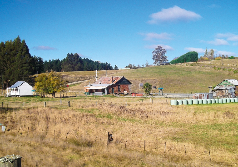
Originally known as The Junction, renamed Tuapeka in 1863, the town became Lawrence in 1866, a more permanent community than that of the tents, shanties and shops of Gabriel’s Gully.
To discover its history, I stepped inside Herbert & Co.’s old grain house which now houses Tuapeka Goldfields Museum and Visitor Centre on Ross Place, the main street. Age old gold mining equipment including shovels and sluices sit alongside information on water races, stamper batteries and dredging. Stories and photos of settlers and miners include that of shepherd George Munro, a Scotsman, and his wife, Helen, regarded to be Tuapeka’s first settlers. There are also tales of ‘Cranky Joe’, a Chinese man who would run six miles from his home barefooted until he neared town, at which point he’d put his boots on. While he would always be reasonably dressed for town, he apparently preferred sacks at other times. Artefacts – bowls, spoons and abacus – are from the original Chinese Camp established in 1867, where Chinese miners lived (Lawrence Borough Council forbade them from living and working within the town boundaries). A restored, late 19th century, one room, mud-brick cottage is furnished with typical household items of that era. Among early farming equipment and wagons, the red wooden Cobb & Co. carriage is a standout. Then there’s the 1978 newspaper article on circus lions running amok in town…and the dead fly display.
Lawrence Heritage Trail
Back out on quiet Ross Place, with a Heritage Trail brochure from the Visitor Centre in hand, I wandered below verandahs of weatherboard and red-bricked buildings interspersed with more modern structures. Plaques on exterior walls gave details of past owners and uses, or details of buildings housing bootmakers, butchers, the news agency and general merchants. The name F. Martin still graces the façade of a red-brick former bakery. Painted purple, the old Town Hall was built in 1875 of stone and brick; its replacement at the street’s other end, built in 1935, is art deco in style and now home to a factory.
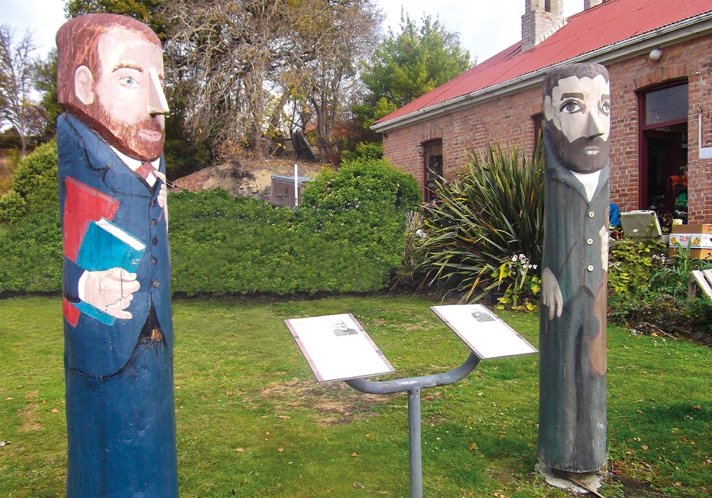
Four figures, of early settlers, stand tall on the street side. In a window frontage, I discovered the first bicycle constructed in New Zealand was built here by Patrick O’Leary, employed by a blacksmith, in 1893. I wonder how that bike would fare today: the Clutha Gold Cycle Trail, which currently stretches between Roxburgh and Lawrence, is being extended from Lawrence for an additional 63km to Waihola, south of Dunedin. The ride, which includes a series of old railway tunnels, rolling farmland, wooded glades and a boardwalk around the Waihola Wetlands, is due to open in March 2023.

Colonsay Street, parallel with Ross, is home to two of the town’s oldest buildings: the former brick Post Office (originally the Warden’s Court), and the concrete Courthouse, both built in 1866. Further along, the 1892 St Patrick’s Catholic Church, now privately owned, stands tall and looks down onto Ross Place. Be sure to pop into the crimson-painted, 1863-built Methodist Church on Whitehaven Street, which has some cute, colonial cottages. Now an antique store, the church is museum-like, crammed with memorabilia and collectibles from the past. There are 38 marked sites on the Heritage Trail, including banks, churches, shops and the cemetery. I took a wander to Lawrence Cemetery, situated on a hill on the outskirts of town. Among grand headstones and faded epitaphs, are the graves of many European and Chinese miners and early settlers, including the Munros. The largest tomb contains the remains of Sam Chew Lain, owner of the Empire Hotel in the Chinese Camp.


Chinese Camp
In 1883, the camp had 60–70 buildings; hotel, shops, gambling and opium dens, joss houses and homes for 40 families. Along with its stables, the red-brick hotel, built in 1884, still stands on the site of the camp on SH8. The only other building is a white weatherboard cottage, Poon-Fah joss house. Used for worship and as a meeting place, this Chinese temple dates back to 1869.
This camp was the main Chinese gateway to the Otago goldfields, although many moved on in the early 1900s when gold dwindled, with the last resident dying in 1945. It is now a heritage site with more restoration work planned. Panels show a map of the camp and historic photos taken around 1904 of small wooden cottages lining one of its streets, with stories of Sam Chew Lain, Chow Tie – a court interpreter, and Chau Mong – a merchant.
How Gabriel’s Gully got its name
After hearing of gold findings by labourer Edward Peters (“Black Peter”), farmer and prospector Gabriel Read arrived in New Zealand from Tasmania in 1861 to explore the area now known as Gabriel’s Gully and struck lucky. It was this discovery that started the gold rush in May 1861.
A walk through time
I headed four kilometres up Gabriel’s Gully Road to Gabriel’s Gully Historic Reserve. It’s hard to imagine this rural valley was home to 11,472 back in July 1861. It had nearly double the population of Dunedin at the time. Lawrence today, only has a population of around 450. A 2.6km Interpretation Walk took me past a powder magazine (a cave) where gunpowder used in the mine was stored. I walked through bush, along narrow channels, once water races that fed water to the workings for the sluicing and crushing of gravel to expose the gold, and found Pollard Dam’s earthen wall still just evident. At a lookout I could see the canyon of the Blue Spur site, where the gold was found. A few slate blue, gravel pinnacles remain. The stone foundations of a battery site endure as does an old mine shaft with what looked like a metal wagon in front.
Tuapeka Vintage Club
On my return, I noticed Tuapeka Vintage Club was open, at the site with more restoration work planned. Panels show a map of town end of Gabriel’s Gully Road. Operating on Sundays 1–4pm, vintage car and transport enthusiasts will love the old tractors, wooden farm wagons, cars, farm equipment and combustion engines in the two large sheds. Adding to the history, behind the sheds you’ll find a street of 19th century buildings – a railway cottage, schoolhouse, jailhouse and stables.

The four figures
1. John Joseph Woods.
An advertisement in an 1876 Saturday Advertiser for the Best National Air for a National Hymn, with a prize of 10 guineas, led John Joseph Woods, head teacher at local St. Patrick’s School, which still stands on Colonsay Street, to compose music to go with Dunedin poet, Thomas Bracken’s words. Of 12 entries, his was chosen and ‘God Defend New Zealand’ became the national anthem. John could play 12 instruments and was also the conductor of St. Patrick’s choir. He served as County Clerk from 1876 to 1931 for the Tuapeka County Council and was admitted as an honorary Freeman in December 1931, the first in the British Dominion to receive the honour. Built in 1902, his home at 17 Lancaster Street is known as Anthem House and is a listed Historic Place Category 2 building. Privately owned, there is a plaque attached outlining its history.
2. John Stenhouse.
John Stenhouse, arriving in Dunedin from Scotland in 1864, was appointed to Lawrence School that same year. The school had a roll of 20 pupils at the time and became Lawrence District High School in 1878. In 1891, having been in charge for 27 years, all staff working there had been taught and trained by him. He taught in Lawrence for 46 years.
3. Archibald McKinlay.
Buying a business operating from a tent in Gabriel’s Gully in 1862, Archibald McKinlay, Edward Herbert and John Herbert, all Scotsmen, began trading it as Herbert and Co. In 1868, they built a store in Ross Place. Replaced in 1981, a plaque now marks the site which is on the Heritage Trail. John Herbert sold his interest in the business in 1873 to the remaining partners, with McKinlay buying out Edward Herbert in 1899/1900. A branch was established in 1903 in Waitahuna and by 1904 Herbert & Co. was one of the oldest businesses in Otago, buying gold and selling drapery, groceries, timber, alcohol and grain. Family members continued the business until 1952. McKinlay’s substantial redbrick home can be seen at 20 Peel Street, now home of the Lady of Lawrence B&B.
4. Edward Herbert.
Edward Herbert arrived from Scotland in 1862, and as well as being a partner of Herbert and Co., was the second Mayor of Lawrence, from 1872 to 1874. He promoted the opening of Lawrence School, and later moved to Dunedin. He died in Scotland.
For more information
• For camping options: nzmca.org.nz
• What to see and do in Lawrence: Lawrence.co.nz
• Lawrence Chinese Camp: lawrencechinesecamp.co.nz
• Gabriel’s Gully Interpretation Walk: doc.govt.nz