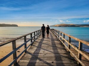
Eleanor Hughes tackles Northland’s notoriously challenging Cape Brett Walkway and discovers the track is true to its reputation of being not for the faint of heart.
With sublime coastal views and rugged bush terrain, the Cape Brett Walkway is a worthy hike to knock off your list if you’re a keen tramper. Our party of four ranged in age from 50 to 70, and we’re all pretty experienced; this is not a walk for first-timers.
The trail runs from Oke Bay to the tip of the Cape Brett Peninsula and is 16km (about eight hours’ walk) each way. However, for a much shorter walk in of around three and a half hours, you can take a water taxi to Deep Water Cove.
A DOC hut provides overnight accommodation at the peninsula, but check the track website to ensure there is fresh water available. Sometimes there is none, so hikers are advised to carry two days’ worth, regardless.
While there is no track parking available, several locals allow visitors to park overnight for a small fee. So, with hut bookings made and the $40 per person track charge paid, we set off. We parked on the front of 243 Rawhiti Road for a $10 donation and set off for our 12.30pm water taxi. Campers and caravanners can park up at Kaingahoa Marae, also on Rawhiti Road – and one of the very few marae operating a campground on the same whenua.
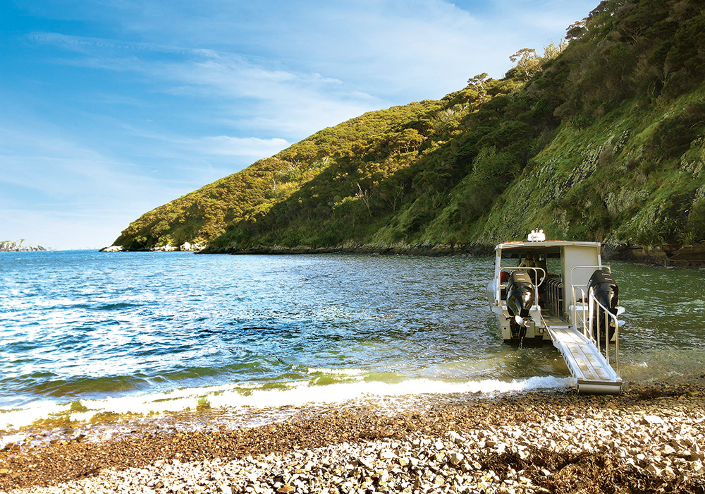
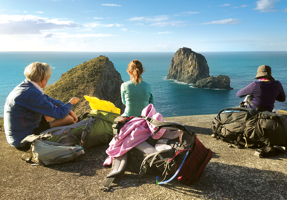
Boat pick-up is off the beach opposite the trailhead. The 30-minute trip took us along the bush-covered northern coastline of Cape Brett Peninsula and past several islands. In horseshoe-shaped Maunganui Bay, we disembarked at Deep Water Cove, nestled below a towering rock face at its eastern end. A sign stated ‘Cape Brett Hutt 2 hours 30 minutes’.
From Deep Water Cove
With a pack that weighed around 9kg, consisting of only essentials, I followed the others on the uphill trail. Entering the bush, I looked back down onto Deep Water Cove. The sea, a mingling of sapphire and aquamarine shades, enveloped islands and stretched into the distance, ending at multi-green, rolling hills… or perhaps they too, were islands.
With many catch-the-breath stops, we zig-zagged up, up, up, hearts pounding. Twenty minutes later, we reached the main track running from Oke Bay; we’d covered just 700m. A sign stated ‘Cape Brett Hut 5km/2.5 hours’. Which sign was correct?
Shaded by wind-blown mānuka, I looked down on coves, the sea an incredible turquoise in one. Soon after, views opened to reveal the peninsula end, rugged, bush-covered and narrow. We wound back into bush, passed water trickling down rocks and marvelled at more stunning coastal scenes, white water forming a ribbon between land and sea.
Descending through shoulder-high, wind-blown, pinkish-brown scrub, before reaching an open, lush grassed area atop a plunging cliff. On the right, an almost vertical rockface, a patchwork of rusty-orange, grey and sage, dwarfed me as I stood precariously close to the edge and peered down, wavering in the wind. The cobalt sea sounded like heavy traffic as it pounded against far below rocks.

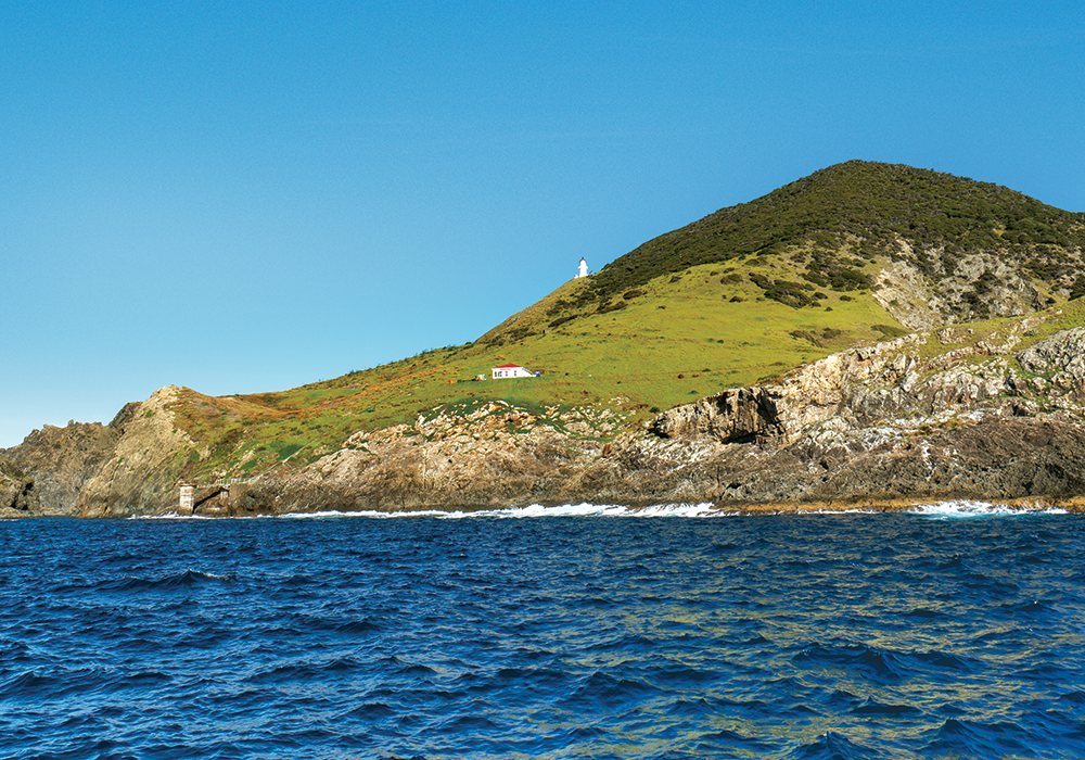
The Lighthouse
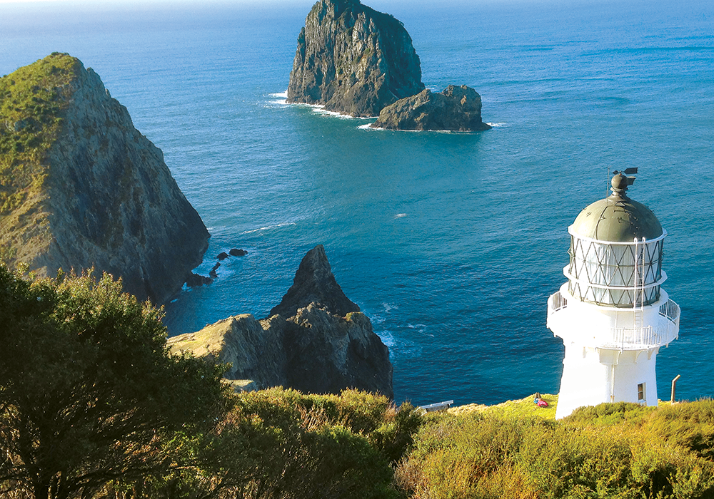
Onwards and upwards along a narrow ridge, a steep drop-off to the right, an orange plastic mesh fence, half fallen down, offered little safety. Numerous stops on the steep ascent were needed before arriving at the highest point. Somewhat perilously, the trail descended towards the lighthouse dome, revealing more and more of it. Nearly three hours from Deep Water Cove we reached the 35ft high lighthouse’s base, 490ft above sea level. First lit on 21 February 1910 and electrified in 1955, its light was able to be seen up to 48km away. It operated until 1978 when it was decommissioned and a beacon, still functioning, was installed.
Cape Brett Hut and Settlement
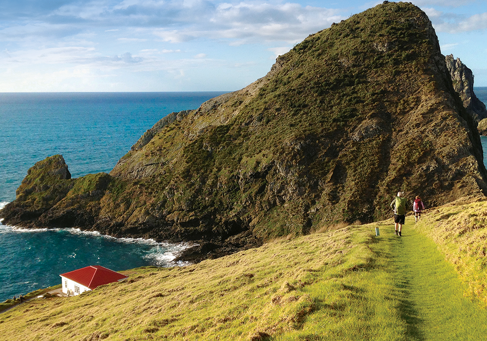
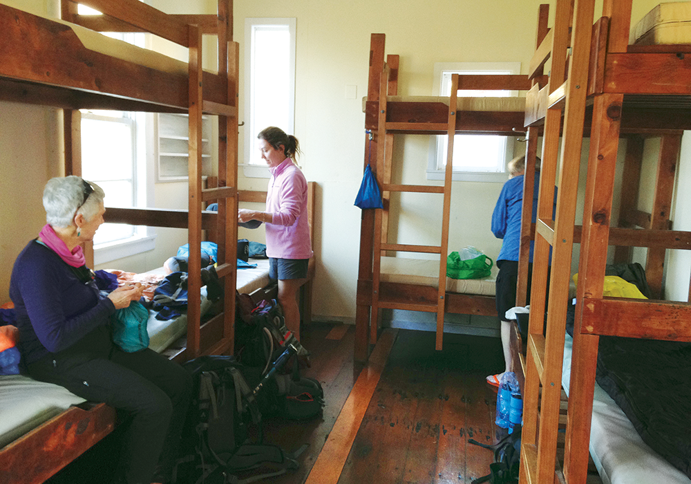
We reached Cape Brett Hut about 30 minutes later. The hut was once the First Assistant Keeper’s House, built around 1909. In the 1990s it was converted to sleep 23 in three bunkrooms, the kitchen area enlarged, and compostable toilets erected at the back of the building.
Having nabbed a bottom bunk, I found enough energy for a wander. The hut looks out to the sea, which is 46m below it. To the left, perhaps 100m away, a headland plunges almost vertically to the water. Old concrete foundations remain that were once cowsheds, a powerhouse and the Principal Keeper’s home, according to the Cape Brett Lighthouse Hut Book at the hut. The book includes stories, memories, and facts on the peninsula’s settlement. A third home once stood 100m or so to the other side of the DOC hut, a schoolhouse between.
I walked down the old tramway — a steep, concrete ramp still sporting rusting rails, to the concrete landing at the bottom where the ocean heaved a fair distance below. The crane used to unload supplies, mail, animals and even a piano from boats is long gone. Storms have washed away much of the ramp, damaging the landing also. In rough seas, boats had to dock in Deep Water Cove and passengers and goods were walked in.
More than 100 keepers looked after the radar station during the time it operated, doubling up as postmasters, butchers, gardeners, mechanics, carpenters, painters, and weathermen. During WWII, the population of the settlement was at its highest with naval staff stationed at the radar station. The hut book’s photos show this remote area was once a busy little place.
Tramping boots donned, and our packs several kilos lighter from consuming most of our supplies, we set off the next morning at 8.20am, retracing our steps to Deep Water Cove turnoff and then heading for Oke Bay.
The first section of trail descended, muddy and slippery. Then it seemed to incline forever, sometimes quite steeply. Coastal views were spectacular; stops were frequent. We lunched with stunning views of the vivid Pacific Ocean, and the bays and peninsulas of perhaps Whangārei Heads.
Six hours in, we reached an electric fence crossing the width of the peninsula, constructed to reduce possums’ impact on the bush. We made it through the gate, and minutes later found a compostable toilet with a scenic view of an island-dotted sea. Later a sign stated ‘Oke Bay – 3km, 1h30m’.
From a shelter at a 345m high point, known as Pukehuia, I gazed out over the Bay of Islands; green blots in a blue jelly-like sea framed by native bush.
Gloriously downhill from there, although slow going in steep places, we arrived at Oke Bay eight hours after setting out. Weary, I was thankful we hadn’t walked the entire track in both directions. But although it had been challenging for each of us in varying degrees, we were planning our next adventure on the drive home.

More Information
- Kaingahoa Marae: kaingahoamarae.co.nz/campground
- Water-taxi service: boiwatertaxi.co.nz or seashuttleboi.co.nz
- Oke Bay, the start of the Cape Brett Walkway, is around a 40-minute drive from Russell, or 80 minutes from Paihia. A water taxi is also available from Russell or Paihia.
- DOC information on the trail, hut bookings and trail charge: doc.govt.nz
Recommended Gear List
- Food for dinner: dehydrated meal, breakfast: rolled oats, powdered milk, lunch: wrap, salami, salad ingredients, a few snacks — raisins, nuts, chocolate, muffins
- Three litres of water
- Sleeping bag, pillowcase
- 3 x layers — 2 thermal
- Woollen hat
- Woollen socks
- Hiking boots
- Shorts/trousers for hiking in
- Change of underwear
- Leggings — for around the hut/sleeping in
- Jandals/slippers for hut use
- Raincoat
- Toothbrush, toothpaste, toilet paper, washcloth/wet ones
- Torch
- Pot, plate, utensils, cup, matches
- Camping oven, gas canister — gas elements are available but if the hut is full, it could be a lengthy wait
Looking for motorhomes or caravans for sale in NZ? Browse our latest listings here.