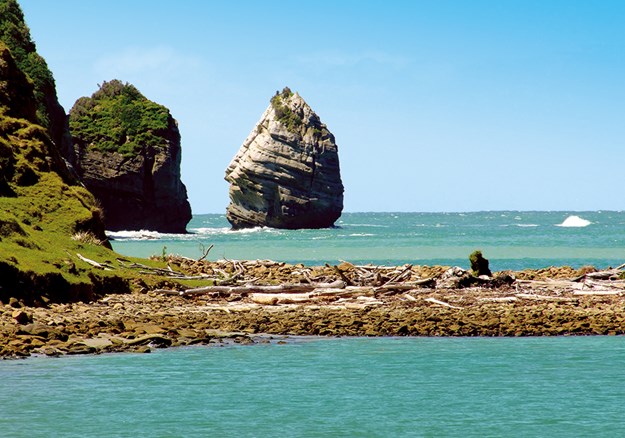
Looking for somewhere new to discover in the North Island? Grab your walking shoes and check out these fabulous walks from Lonely Planet’s Best Day Walks New Zealand.
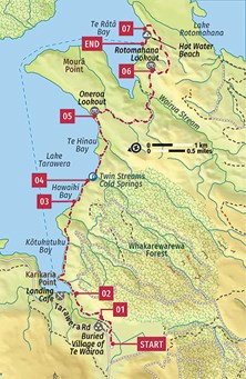
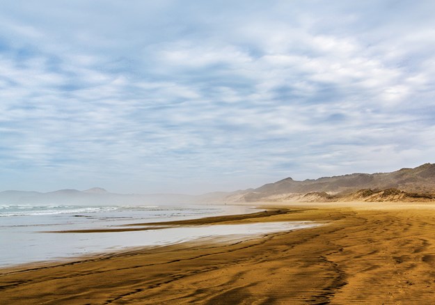
TARAWERA TRAIL
Duration: 4 hours
Difficulty: Moderate
Distance: 15km
Terrain: Undulating lakeside path with one sustained climb near the end
Start/End: Tarawera Rd/Hot Water Beach
Few walks in the world end with such reward as the Tarawera Trail. After following Lake Tarawera’s southern shores, this fine walk finishes on Hot Water Beach, where you can soak away the effort of the past few hours in geothermally heated waters. Not all the trail’s delights are reserved for the end, however, with the walk passing cold springs and lake swimming opportunities, with views of one of New Zealand’s most storied volcanoes. Hot Water Beach is simply the piece de resistance.
GETTING THERE
The trailhead is on Tarawera Rd, 15km from Rotorua and 2.5km before Lake Tarawera. Totally Tarawera (totallytarawera.com) runs a water taxi to and from Hot Water Beach; pickup includes a return shuttle to the car park. Bookings required.
STARTING POINT
The trail’s large car park has toilets and a rainwater tank beside a Maori pou (ancestral carving). 01 The trail to Lake Tarawera sets out through the Te Wairoa valley. To your left as you cross the bridge over the gin-clear Te Wairoa Stream is the former village of Te Wairoa, buried beneath ash in Mt Tarawera’s 1886 eruption. From the stream, the trail ascends gently to the Te Wairoa Valley Lookout, which offers a peep down into the valley and the buried village.
02 As you descend from the ridge, you’ll be accompanied by the sound of unseen Wairere Falls, before the trail follows the valley to the shores of Lake Tarawera.
03 Soon the trail rounds Karikaria Point and ambles along Kotukutuku Bay. The first time you come to the water’s edge is at Hawaiki Bay, where there are picnic tables, a sandy beach and good views of the hulking figure of Mt Tarawera.
04 From here, the trail rises back above the shore and into cool, fern-dominated forest. The trail descends back to the lake on a set of wooden steps and soon crosses the Twin Streams Cold Springs, where four cold springs rush out of the earth.
05 The trail runs set back from the shore for about 20 minutes, before starting its ascent over the long finger of Moura Point, rising to Oneroa Lookout and a keyhole view across the lake.
06 From the lookout, the trail cuts across the point before descending to Wairua Stream, which has picnic tables and a toilet. The stream marks the start of the trail’s most significant climb, cutting at first beneath crumbly rock walls and then rising to the overgrown Rotomahana Lookout, which peers across to adjoining Lake Rotomahana.
07 The trail continues on the narrow ridge before slowly lowering to Lake Tarawera’s edge. At the shore, the trail doubles back on itself, finishing along the water’s edge to Hot Water Beach – head for the steam at the far end. Sites at the beach’s campsite must be pre-booked.
TAKE A BREAK
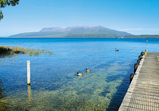
Grab a deck table and ponder the power of Mt Tarawera from across the water at the Landing Cafe (07-362 8502); The Landing, Tarawera Rd; mains $15-36; 9am-8pm, closed for dinner Mon-Wed in winter), a cafe-cum-bar-cum-bistro on the shores of Lake Tarawera.
WONDER NO MORE
Tourism around Lake Tarawera was at its peak in the 19th century, when visitors came to the village of Te Wairoa to be ferried across the lake to the Pink and White Terraces on Lake Rotomahana. The terraces were considered the eighth natural wonder of the world. That all came to an end on 10 June 1886, when Mt Tarawera erupted, killing around 120 people, burying Te Wairoa beneath ash, Pompeii style, and destroying the Pink and White Terraces.
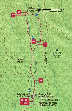 WILKIES POOLS
Duration: 1 hour, 20 min
Difficulty: Easy
Distance: 1.9km
Terrain: Mountain, forest, excellent track
Start/End: Dawson Falls Visitor Centre
This easy walk on the slopes of Taranaki is hugely fun for kids while being gloriously scenic for adults. Highlights include an enchanting ‘goblin forest’ and a set of lava- formed pools with a natural rock slide – we told you kids would love it! It’s a short stroll but there are plentiful options for extending it into something more substantial by joining up with adjacent tracks.
GETTING THERE
The closest town is Stratford, 23km away, or you can drive here from the city of New Plymouth in less than an hour.
STARTING POINT
The Dawson Falls Visitor Centre has a large car park with a toilet. There’s a cafe in the adjacent Dawson Falls Mountain Lodge.
01 From the visitor centre, cross the lawn and look for the well-labelled start to the track. The first 900m is touted as being wheelchair accessible, although you’ll need arms like Popeye for the steep section a little further on. The track heads straight into one of Taranaki’s famous ‘goblin forests’, a gorgeous mossy, fern-filled subalpine wonderland, where the trees all sport long, straggly lichen beards.
02 After a steeper incline, the path reaches the Kapuni Stream and offers magnificent views of Mt Taranaki, directly ahead. You can easily see why the picture-perfect volcano was cast in the role of Mt Fuji in the 2003 Tom Cruise flick The Last Samurai. The path then follows the gurgling rock-strewn stream until it crosses it via a bouncy suspension bridge.
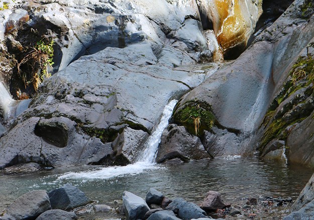
03 Just across the bridge, a short track leads to the Wilkies Pools, a set of small pools formed within 20,000-year-old lava, with waterfalls tinkling into them. A short, steep natural rock slide connects them, which hardy kids delight in swooshing down.
Being hardy is a necessity: the water originated from snow melts further up the mountain and is bracing to say the least. A wetsuit is sensible attire.
04 Pick up the trail again, which is a little rougher and damper on the return loop (it’s still fine, but definitely not wheelchair accessible, and muddy in places). It heads back through more goblin forest and steps down to some picturesque little waterfalls and a small stream. Just after the junction of the Ridge Track, look out for the intake weir for the hydroelectric power station, which you can visit later, just off the road near the car park (built in 1899, it’s the world’s oldest continuously operating power generator).
05 Metal steps head down to the Kapuni Stream, which is easy enough to cross by hopping between the rocks (although it’s impassable after heavy rain). The loop then rejoins the wheelchair-accessible part of the main track; turn left to head back to the visitor centre.
TAKE A BREAK
The cafe (06-765 5457; dawsonfalls.co.nz; 1890 Manaia Rd; mains $6-7.50; 9am-5pm) within Dawson Falls Mountain Lodge has a counter cabinet full of simple savoury and sweet pastries. Alternatively, stock up on supplies in Stratford or New Plymouth and enjoy a picnic by the pools.
EXTEND YOUR TREK
If 80 minutes isn’t enough to get your blood pumping sufficiently, there are various options for continuing your walk. The simplest is to cross the Dawson Falls Visitor Centre car park and look for the start of the Kapuni Loop Track, a one-hour (1.4km) circuit through more ‘goblin forest’ alongside the Kapuni Stream to the base of the 18m-high Dawson Falls. The track then climbs steeply to the falls lookout, crosses the road and continues back through forest to the visitor centre.
Alternatively, you can link the Wilkies Pools and Kapuni Loop Tracks via the Ridge Track (one hour). This also avoids the short double back at the end of the Pools Track.
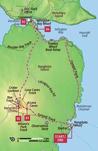 RANGITOTO SUMMIT LOOP
Duration: 4.5 hours
Difficulty: Moderate
Distance: 14km
Terrain: Scoria track, road, rough in parts
Start/End: Rangitoto Wharf
Experience a unique terrain of scoria and pohutukawa forest on a climb up Auckland’s youngest and largest volcano. Rangitoto Island is only 25 minutes by ferry from central Auckland, yet a world apart. It slopes elegantly to its 260m-high summit, offering magnificent views over the metropolis and surrounding islands. In 2011, after an extensive eradication programme, it was officially declared predator-free and it now teems with birdlife, including several endangered species.
GETTING THERE
Ferries run by Fullers 360 (fullers.co.nz; adult/child return $36/18) depart from Pier 4 on Auckland’s Quay St; you’re best to book in advance, online.
STARTING POINT
There’s a shelter, seating, information boards and toilets at Rangitoto Wharf, but that’s it. There’s no food or drinkable water on the island, so stock up beforehand. Pay special attention to the timing of the return boats before setting out. If you miss the last one, you’ll be faced with a very expensive watertaxi ride back to town.
01 From the wharf, pass through the carved Maori gateway and follow the signs marked ‘Rangitoto Summit’.
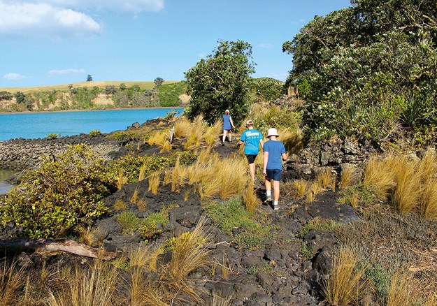
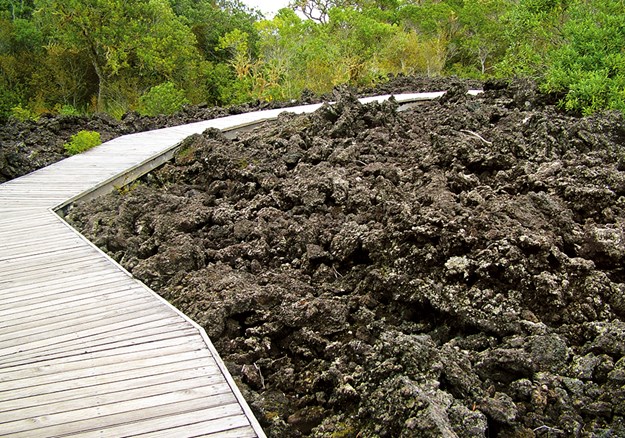
A well-formed gravel track leads to the top, sloping gently at first but eventually reaching some stepped sections. Pohutukawa trees and low scrub rise tenaciously from the dark volcanic stone, although you’ll also cross barren lava flows where they’ve yet to take hold. After 30 minutes there’s a clearing where you can take a 15-minute (each way) detour to some lava caves.
02 Continue on the main track for a further 15 minutes and you’ll reach the 60m-deep and 200m-wide crater, filled with lush native bush. Follow the Crater Rim Track clockwise to the summit. Here, there’s a viewing platform offering exhilarating views of Auckland.
03 Complete the crater circuit and, at the junction, follow the signs to Islington Bay Wharf along the stepped boardwalk. After 10 minutes you’ll pop out on a dirt road; the only traffic you’re likely to encounter is the Volcanic Explorer 4WD road train. Turn right and head down the road for 45 minutes, following the signs to Islington Bay Wharf at every junction until you see a sign pointing towards Motutapu Island. After 500m you’ll reach the causeway over the narrow channel separating the two islands. There’s a cute little beach on the Motutapu side.
04 Pick up the track by the bridge to Islington Bay Wharf, which skirts the edge of a gorgeous estuary. After the wharf, keep following the Islington Bay Track along the coast. Turn left when you hit the road, which terminates shortly afterwards, at Yankee Wharf. From here, follow the signs reading ‘Rangitoto Wharf via Coastal Track’. It follows the coast before cutting across the volcanic rock on a rough track through the bush. Eventually, it comes out alongside the water for the final leg to the jetty.
TAKE A BREAK
There are no shops or eateries on the island, but the ferries have cafes serving pastries and drinks. If you’re looking for a pre- or post-walk fuel stop on the city side, try the nearby Britomart precinct. Options include The Store (thestorebritomart.nz) and Amano (amano.nz).
AUCKLAND VOLCANIC FIELD
Some cities think they’re tough just by living in the shadow of a volcano; Auckland’s built on 50 of them. The last one to erupt was Rangitoto, about 600 years ago, and no one can predict when the next eruption will occur. Auckland’s quite literally a hot spot – with a reservoir of magma 100km below, waiting to bubble to the surface. But relax: this has only happened 19 times in the last 20,000 years.
Some of the volcanoes around are cones, some are filled with water and some have been completely quarried away. Moves are afoot to register the field as a World Heritage Site and protect what remains.
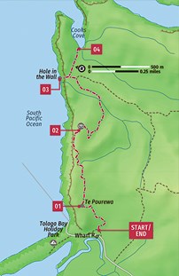 COOKS COVE WALKWAY
Duration: 2-2.5 hours
Difficulty: Easy
Distance: 5.8km
Terrain: Undulating farm tracks broken by a few steeper climbs
Start/End: Wharf Rd, Tolaga Bay
Human history and natural history delightfully intersect on this beautiful coastal walk north of Gisborne. The end goal is one of Captain James Cook’s most famous landing sites though, to get there, you have to traverse a gorgeously eroded section of coast. There’s the chance to explore a huge cave naturally burrowed through the cliffs, with a view to NZ’s longest wharf. Note that the track is on private land, and is closed for lambing season from August until late October.
GETTING HERE
The walkway starts near the end of Wharf Rd outside of Tolaga Bay; the turn-off is signposted on SH35, 53km north of Gisborne.
STARTING POINT
The walkway car park has space for around a dozen cars. If it’s full, head about 200m down the road to the car park for the Tolaga Bay Wharf. There are no facilities at the walkway car park, but a few signboards offer some track and history information.
01 Through the wooden barrier, the walkway begins an immediate climb, snaking up the slopes through light bush. Near the top, cross a fence on a stile and continue through an open paddock towards the tall arrow-shaped sculpture, Te Pourewa – the Beacon of Light, which honours ancestors who kept a flame burning here. Wander around the sculpture to get a good view along the Tolaga Bay beach.
02 From here the walkway follows farm tracks cut below the lip of the cliffs, stepping across another stile and then rising more steeply. Just past the cabbagetree- topped high point, the walk dips to a lookout and your first view into Cooks Cove, nibbled into coast 120m below where you stand. Catch your breath here as most of the climbing is done (at least until the return leg).
03 From the lookout, the track descends rapidly on wooden steps, funnelling through a narrow fern-covered gully and bottoming out across a bridged stream. Just downstream from the bridge, you’ll pass a side track that heads a few metres into Hole in the Wall. Spend some time exploring this ocean-scoured cave that’s like a tunnel through the cliffs. Pop through the hole and you’ll find a view of the Tolaga Bay Wharf – NZ’s longest (660m) – and the high cliffs across the bay.
04 Return through the hole to the main track and turn left, crossing the grassed area to reach Cooks Cove, which looks barely wide enough to shelter Cook’s ship, Endeavour. Depending on the tide, you can head out into the sands and shores, where there are good views of the Mitre Rocks, which are ranged like sharp teeth across the mouth of the cove. Return to the car park along the same route.
TAKE A BREAK
Tucked into the end of the Tolaga Bay Inn, welcoming Aunty’s Cafe (06-862 6856; 12 Cook St, Tolaga Bay; meals $17-27; 10am-2pm & 5-8pm) serves up fresh-baked scones, plus breakfast, lunch and steaky dinners. Grab the guitar and have a post-hike jam. Or head down to the Tolaga Bay Wharf where you’ll likely find Broad Bills, a caravan serving up a range of pizzas plus smoothies, chips and drinks.
A CHEERY COVE
In October 1769, less than three weeks after first making landfall in New Zealand, Captain Cook’s Endeavour sailed into the cove that now bears his name but was known to the local Te Aitanga-a-Hauiti tribe as Opoutama.
Cook anchored here for six days, and it was a remarkably harmonious interaction between the crew and the Te Aitanga-a-Hauiti. Goods were traded and the Endeavour took on supplies of water, food and wood.
Things went so well that the Te Aitanga-a-Hauiti named a couple of places (and future children) after Tupaea, the Tahitian high priest aboard the Endeavour.
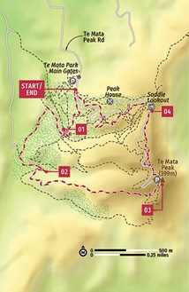 TE MATA PEAK
Duration: 2-2.5 hours
Difficulty: Moderate
Distance: 5.5km
Terrain: Open hilltops with some steep and exposed climbs
Start/End: Te Mata Park main gates
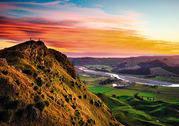
For a hill that tops out at just 399m above sea level, Te Mata Peak offers ridiculously good views. Seeming to bubble up from the Heretaunga Plains behind Havelock North, the peak’s open ridges and summit provide 360-degree panoramas across almost the entirety of Hawke’s Bay.
GETTING THERE
Te Mata Park’s main gates and car park are on Te Mata Peak Rd, 5km southeast of Havelock Park. ere’s no public transport to the park.
STARTING POINT
The car park immediately beyond the park’s stone gateway is set beneath tall Californian redwoods. An open-topped shelter above the car park has maps and park information, and there are toilets and tables beside the shelter.
01 The various walks in popular Te Mata Park are colour-coded – the route described here is the Rongokako Trail, which is marked with blue triangles and is the most dramatic of the park’s walks. It starts at the shelter above the main gates, heading up immediately beside the road. Along the right edge of the trail, you’ll notice (and probably smell) the white trunks of the yellow scented eucalypts – imports from Australia. By the Te Aratipi mountain-bike track junction, the walk turns away from the road and descends gently into a large grove of Californian redwoods. In their native North America, these redwoods, or sequoias, are the planet’s tallest trees.
02 The walk zigzags up a slope, weaving through the redwoods. The trail soon seems to overhang a deep, narrow valley and you’ll be looking across the tops of the redwoods that grow from it. Turning left by a fence, the trail bottoms out among the most impressive section of redwoods, where it crosses a stile and emerges into open grassland.
03 The summit climb begins here, winding onto, and then along, a broad ridge. There are some precipitous sections along the ridge, with steep drop-offs and a short scramble up a well-stepped rock face known as the Goat Track (it’s better ascended than descended). Crossing a narrow gap in the ridge, the final steep climb awaits, rising to the summit, which you’ll share with those who drove up the road. The view from the summit stretches along Te Mata’s hog’s back ridge and takes in Napier, Hastings, the Mahia Peninsula, the Ruahine, Kaweka and Maungaharuru ranges, and even distant Mt Ruapehu on a fine day.
04 The blue triangles continue directly across the summit car park, where the track rolls across the lumps and bumps of the ridge to Saddle Lookout and a view back to the summit. The walk cuts across the inside corner of the road (past a drinking fountain) and back into the cover of bush. It descends quickly to cross Te Mata Peak Rd just below Peak House, continuing down to the main gates and car park.
TAKE A BREAK
Around 1km up the road from the park’s main gate, with a grand view of its own, Peak House (thepeakhouse.co.nz; 357 Te Mata Peak Rd, Havelock North; h7am-3pm Wed-Sun) is a lodge-like coffee, beer or wine stop with a breakfast style menu (avocado on toast, muesli). There are several points on the final descent where you can branch off to the cafe.
THE SLEEPING GIANT
Te Mata Peak is known as the Sleeping Giant for the shape of its profi le (a likeness that’s most obvious when seen from around Hastings) and for its connection to the legend of Waimarama chief Te Mata. The rival Pakipaki people enticed Te Mata into falling in love with Hinerakau, the daughter of a Pakipaki chief. In order to prove his love, Te Mata was set a series of tasks, including biting his way through the peak that now bears his name. In doing so, he choked on the earth and died. His body became Te Mata Peak – you’ll pass the bite, or The Gap, between the summit and Saddle Lookout.
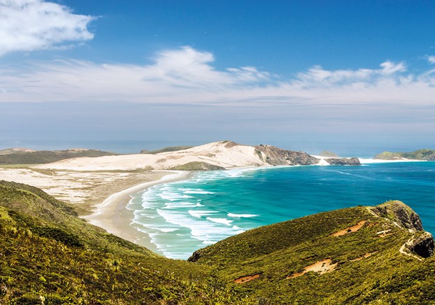
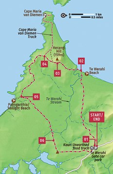 TWILIGHT TE WERAHI LOOP
Duration: 4.5 hours
Difficulty: Hard
Distance: 16km
Terrain: Fields, bush, dunes, rocky slopes
Start/End: Te Werahi Gate car park
Explore an extraordinarily beautiful and eerily empty strip of coast at the very tip of the country. The track passes through farmland, native bush, bird-rich wetlands and intriguing dune ecosystems before hitting blissful beaches and multicoloured hills.
GETTING THERE
The trailhead is 4.5km shy of Cape Reinga, which is the very end of State Highway 1 (SH1). There’s no public transport to these parts.
STARTING POINT
Aside from plenty of parking and a lunchtime-only food truck, there’s nothing at the start of the track. The nearest public toilet is at Cape Reinga.
01 We recommend tackling this loop in a counter-clockwise direction to avoid a steep scramble back up the sand dunes. Large sections of the track aren’t well formed, so keep an eye out for the orange route markers mounted on poles. Start by crossing over the stile onto the field and following the fence down through the farm. A dirt track then leads through a patch of low scrub. Head over the stile and take the boardwalk across the marsh, through a corridor of tall reeds.
02 A patch of dappled scrub follows, before opening out into a sandy terrain punctuated by toetoe (a tall native grass with distinctive feathery plumes). The route then drops down steeply into a broad expanse of dunes, anchored by rope-like strands of grass. There’s no real track here; look out for the orange markers. The route edges a swamp before coming out onto the southern end of 3km-long Te Werahi Beach.
03 Walk along the sand edging the sinuous loops of Te Werahi Stream, then wade across and climb to the signpost on the headland. Around the next bend, pretty Cape Maria van Diemen comes into view and you’ll enter an unusual landscape of artfully eroded gullies and colourful patches of pink, peach and orange claycoated stone. Some of this section is quite steep and it can be difficult to spot the orange markers against the peach coloured slopes of Herangi Hill.
04 Around 2km after Te Werahi Beach, you’ll reach the junction with a side track leading to Cape Maria van Diemen, the North Island’s westernmost point. If you’ve got 90 minutes to spare, it’s worth the 2km (each way) detour to what looks like rocky islets, anchored to the shore by sand dunes. If not, content yourself with the gorgeous views from just up the next hill.
05 The next 3km of track is rough and steep before it eases into a smooth stretch through low scrub heading for the northwestern end of remote Paengarehia/Twilight Beach. Stop to watch the breakers rolling in along the empty beach before starting your return journey.
06 The final leg takes around 80 minutes and, in places, can be a bit of a slog. Start by heading across the scrubby dunes before delving into the shady patch of bush. Another reed-lined boardwalk follows, and then another patch of bush before the route heads up through the cattle farm. Stick to the fence to avoid the bulls.
TAKE A BREAK
The Kauri Unearthed food truck serves burgers, nachos, and fish and chips from the trailhead car park, operating from roughly 11am to 3pm in summer. Hours are sporadic in winter.
CAPE REINGA
SH1 terminates at this dramatic headland where the waters of the Tasman Sea and Pacific Ocean meet, breaking together into waves up to 10m high in stormy weather.
Cape Reinga is the end of the road both literally and figuratively: in Maori tradition the spirits of the dead depart the world from here, making it the most sacred site in all of Aotearoa. Out of respect, you’re requested to refrain from eating or drinking in the vicinity.
The actual departure point is believed to be the 800-year-old pohutukawa tree clinging to the rocks on the small promontory of Te Rerenga Wairua (Leaping Place of the Spirits) far below; access is forbidden to those in corporeal form.
.jpg)
Lonely Planet’s Best Day Walks New Zealand is available where all good books are sold. RRP $36.99