Seasoned traveller Lisa Jansen explores one of New Zealand’s most scenic drives and finds history, activities, dams, and stunning scenery along the way
If there were a competition for the most scenic road in New Zealand, picking the winner would be no easy task.
However, one that would surely be a contender is State Highway 83 along Waitaki Valley, which takes you from the coast just north of Oamaru to Omarama, about 110km inland. As a bonus, this one is fully sealed and suitable for all vehicles, unlike many other scenic drives.
While the road is beautiful driven in either direction, heading inland from the coast is possibly slightly more spectacular, especially on a clear day because you’re heading towards the mountains. To start this scenic trip, turn off SH1 at Pukeuri, about 9km north of Oamaru. For the first 35km, the road will take you through farmland, which, while beautiful, might make you wonder why this is considered one of the most beautiful roads in New Zealand. Be patient.
Duntroon: Elephant Rocks, Wetlands Walks, and Vanished World

Just east of the small settlement of Duntroon is the first sight worth stopping for (or the last if you’re coming from the other direction): The Elephant Rocks.
These large, hummocky rock formations were created from the erosion of millions of years old, fossil-rich limestone. The result is a field filled with large boulders of various shapes and sizes that, with a bit of imagination, look like a herd of elephants – hence the name.
The Elephant Rocks are the most famous stop on the Vanished World self-driven tour, a 35km/40-minute trail that showcases key geological sites in North Otago. Stop at the Vanished World Centre in nearby Duntroon and grab a map (or download it from the website).
Even if you don’t plan to drive the trail, Duntroon is still worth a stop. In addition to the Vanished World Centre, there are pretty old buildings, a café, and the Wetlands Walk with excellent information panels. The walk is 11km in total but even shorter sections are worth doing.
Kurow: History, Richi McCaw, and Cinnamon Scrolls

From Duntroon, continue west on SH83 for about 23km, and you will arrive in Kurow, best known as the boyhood home of All Blacks legend Richie McCaw. However, even if you’re not a rugby fan, you’ll likely want to stop in Kurow.
Visit the Kurow Museum to learn about the story of the Waitaki Valley, take a photo with the giant Rich McCaw statue, pick up supplies at the Four Square, and wander through the shops and gallery along the main road. Kurow is also a great place to stop for lunch or refreshments, with several cafés to choose from. If you have a sweet tooth, the delicious cinnamon scrolls at the Waitaki Braids Cafe will likely make your day.
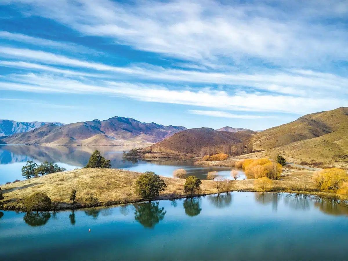
Shortly after leaving Kurow, heading inland, you will start to see just why this is considered one of New Zealand’s most scenic drives. As the Waitaki River widens into Lake Waitaki and then Lake Aviemore, the scenery becomes ever more beautiful. You will drive along clear lakes, surrounded by golden hills and mountains. On a clear day, you can even see the Southern Alps in the distance.
The Waitaki Hydro Scheme

The Waitaki Valley is not only beautiful but it’s also powerful – full of hydropower, to be specific. The Waitaki hydro scheme, which consists of eight power stations between Takapō and Lake Waitaki, generates enough electricity each year for more than 850,000 average New Zealand homes.
The first glimpse of the Waitaki hydro scheme is Waitaki Dam at the eastern end of Lake Waitaki. There’s a well-sign-posted lookout with ample parking about six kilometres west of Kurow. Continue on SH83, and you will soon see Aviemore Dam, which you can cross by car or foot. From here, you can continue west on SH83 or follow Te Akatarawa Rd on the other side of Lake Aviemore to Benmore Dam and then take Lock Laird Rd back to SH83.
Both roads are fully sealed and offer beautiful views. There are several campgrounds along Te Akatarawa Rd, so if you’re looking for a spot to spend the night, that might be the better option, though the road is narrower than the State Highway.
If you continue west on SH83, make sure you take the detour to Benmore Dam, as this is a particularly stunning part of this trip.
Benmore Dam is the largest dam in New Zealand and the second largest hydro station, with a generating capacity of 540 megawatts (only Manapouri generates more). Construction for this impressive dam began in 1958, and it started operating in 1965. You can drive, walk, and cycle across the dam, and it’s a sight you don’t want to miss.
Lake Aviemore: Lake views, cycling, walking, and camping

Lake Aviemore isn’t just a pretty sight. There’s lots to do and see in the area, so why not set up camp at one of the many lakefront sites and enjoy the scenery for a few days?
While most of the mobile apps only show a small number of campsites along Te Akatarawa Rd on the northern side of Lake Aviemore, there are, in fact, numerous options. In addition, there are several camps along Loch Laird Rd. If you prefer to stay on SH83, you can find lakefront campsites at Parson Rock and Sailors Cutting, though be prepared for some road noise. They are
all council-operated camps with basic facilities (sometimes quite a walk away from the sites), so don’t expect Top10-like luxury. But the views and serenity more than make up for it. Be aware that the camps get busy over the summer, with many families coming here each year for their holidays. However, outside of the summer school holidays, you shouldn’t have any issues finding a
good spot.
Once you’ve set up camp, it’s time to explore. Cyclists will love riding the Alps2Ocean trail. The section from Benmore Dam to Sailors Cutting is particularly spectacular. However, it includes a couple of climbs, so a moderate level of fitness (or a good e-bike) is required. For a more leisurely ride, head east from Benmore along Te Akatarawa Rd or ride from Benmore to Otematata, where you’ll find a few little shops and often some food trucks in summer.
If you prefer to explore on two feet instead of two wheels, you also have several options. The Benmore Peninsula Loop, which starts at Benmore Dam, is a four-kilometre loop track that offers fantastic views all the way to Mt Cook on a nice day. It’s steep in parts, so a moderate level of fitness is required. A slightly easier but also beautiful option is the Deep Stream Track at the northeastern end of Lake Aviemore. And, of course, you can also walk sections of the Alps2Ocean trail. In addition, you can find a golf course in Otematata.
The lake is also an excellent place for all sorts of water sports, from boating to fishing, wakeboarding, kayaking, paddleboarding, and more. Just make sure you stay well clear for the dams.
Once you’re able to tear yourself away from this beautiful part of the country, continue on SH83 until you reach Omarama. From here, you can turn north and explore the Mackenzie Basin or head south over Lindis Pass towards Central Otago. Whichever option you choose, you will continue to enjoy stunning scenery. We’re indeed lucky here in New Zealand.