 |
|
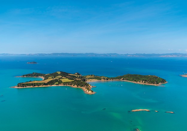
Aerial shot of Rotoroa Island
|
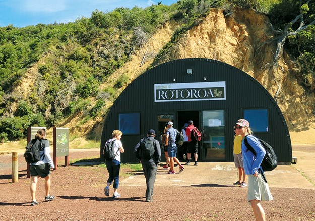
An hour and a quarter after leaving downtown Auckland I stepped ashore onto 80ha Rotoroa Island, tucked behind Waiheke and Ponui islands, and not far from Pakatoa Island. Welcomed by Rotoroa rangers at the wharf, we filed into a large shed. The walls were covered in information on kiwi and pests, and Ranger Jo told us a little of the island’s history and of the walks available. I set off to explore.
EXHIBITION CENTRE AND HISTORY
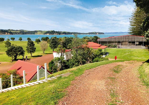
A short walk from the wharf, along Home Bay’s waterfront, brought me to a line of Norfolk pines. Originally there were 12 trees, representing the 12 steps of the Alcoholics Anonymous programme (due to lightning and disease there are now only 10). A metal ramp incised with the numbers 1–12 also reflects this, and leads to the Exhibition Centre, designed in the style of a woolshed to blend into the surrounds.
 |
|
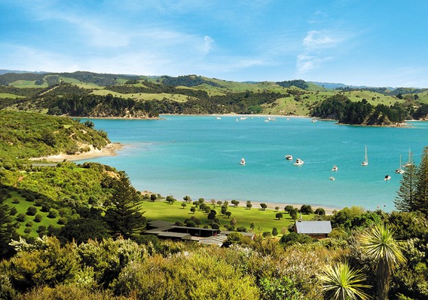
Home Bay from North Tower
|
Inside the centre I discovered more of the island’s history. Purchased by Charles McIntosh from Hauraki Māori chiefs in 1841, it was subsequently bought by William Ruthe in 1886 to create a tourist, holiday and health resort. In 1908 the Salvation Army acquired it for a facility for ‘inebriates’, as the existing building on Pakatoa Island was too small. The men’s rehabilitation centre was opened in 1911. I learned, from photographs and text, what life was like on the island for Army families and the men who were treated here, and about the Salvation Army itself. With a farm, orchard, and vegetable gardens, the 150 residents were almost self-sufficient. Those receiving treatment worked the land and learned new skills for their future. The facility began receiving women in the 1980s but was eventually closed in 2005.
Behind the Exhibition Centre, where 12 phoenix palms represent the 12 disciples, several old buildings remain: a butchery, a jailhouse (made of bricks from the island’s brickworks) and an 1860s one-room schoolhouse, now used for meetings and education programmes. On a hill overlooking the area is a chapel.
WILDLIFE SANCTUARY
In 2008 the Rotoroa Island Trust was established, purchasing a 99-year lease from the Salvation Army. The trust planted 350,000 trees and today, the island is a wildlife sanctuary open to the public.
RELEASING KIWI
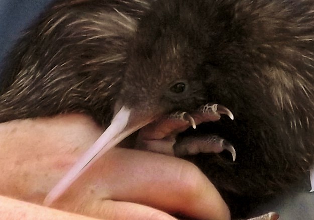
I was lucky enough to be on the island when two kiwi were released. The Rotoroa Island Trust has a partnership with Thames Coast Coromandel Kiwi and Kiwis for Kiwi, part of a programme known as Operation Nest Egg. Eggs are first removed from the wild and taken to a secure facility such as Auckland Zoo. Once the birds have hatched and weigh around 400g (3-4 weeks old), they are brought to Rotoroa. In this predator-free ‘creche’, they’ll spend about two years – to around the start of their reproductive cycle, or on reaching 1200g – before being rehomed.
 |
|
Meeting the kiwi
|
The kiwi arrived on the ferry with us, hidden away, and were given half an hour in a cool, dark place to settle before being brought out to ‘meet the public’. We lined up for a close-up and Ranger Jo carried the birds past, stopping for photos. I was surprised at how big they were at such a young age, and at their strength when trying to escape Jo’s hold. They were later released on the island into purpose-made wooden burrows. In the evening, we were told, they would push through the foliage covering and begin foraging to make their own burrow.
GUIDED WALK
Through Fullers360 I had pre-booked a two-hour guided walk. Setting out from the Exhibition Centre, we were guided by Milly, a ranger who, with her husband and son, are the only full-time inhabitants of the island. We walked past the original home of the Superintendent (the most senior Army staff member), which now has hostel-style accommodation, and heard more in-depth island history. In a shady spot where weka shot in and out of the bush, Milly showed us the trapping and tracking systems for pests. Rotoroa has been pest-free since 2013, but there are a few incursions a year, mostly over summer.
 |
|
The Exhibition Centre, old schoolhouse, jailhouse and butchery
|
To reflect the history of Maori and the Salvation Army, pohutukawa have been planted in what was once the orchard. Once they grow larger and bloom, the land will look as if it’s draped in a red cloak.
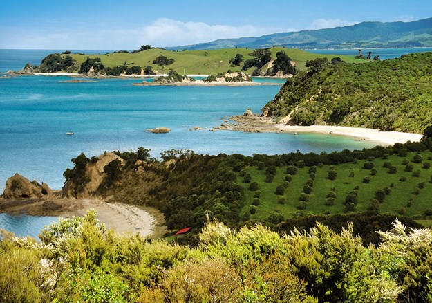
We visited Ladies’ Bay, possibly the most picturesque of the island’s five bays. It’s a small cove of turquoise water and white sand, where pohutukawa were blossoming at its northern end. At the southern tip, past where dotterel sprinted above the high-tide mark, an arch in the rock makes for arty photos. Around the point are views of Men’s Bay, where men were confined to swim, as apparently they swam naked in Salvation Army days. Ladies’ Bay was designated for women and families.
 |
|
Ladies’ Bay, Men’s Bay and Ponui in the background from the cemetery
|
The island has three man-made swamps and we visited one where pateke (brown teal) can sometimes be spotted … but not on my visit, though I did see whiteheads and saddlebacks.
Milly pointed out the cemetery, distant white headstones and crosses marking the 19 graves of patients and Salvation Army members, the oldest dating from 1911. We walked near where the kiwi were released, learning more details of their reproduction and how they are tracked. Further on, in a shady area in the bush, we came across the world’s rarest tree, a Three Kings kaikomako. Grown with a bit of scientific intervention from a graft of what was believed to be the only specimen in the world, 30 saplings are now flourishing on Rotoroa Island.
The tour finished at North Tower, which has spectacular views across to Coromandel, Great Barrier, Waiheke, Pakatoa, Ponui and of the island itself, now forested with 10 years’ growth. It’s a stark difference from early photos Milly showed us, taken in Salvation Army days when the land was bare.
OTHER WALKS
From North Tower I took a downhill, bush trail to Cable Bay, spotting a few cheeky weka chasing each other across the path behind me. There were apparently only nine weka on the island when the trust took over, but they now number over 400.
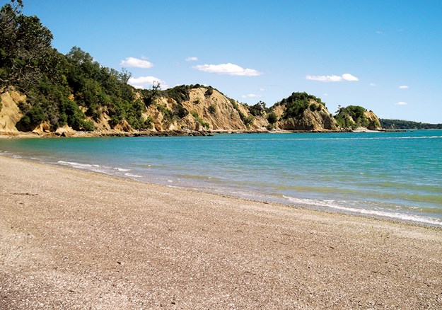
I walked the sandy shores of the long curved beach, over a small amount of rock, to near its end where an uphill, zig-zag bush track leads to a gravel road. Slightly further along this is the 10-minute, downhill Mai Mai Bay track. This more rugged bay has a long, rocky point at the southern end, which looked to be walkable at low tide.
 |
|
Mai Mai Bay Beach
|
Twenty metres or so along the gravel road towards Home Bay, is another 10-minute trail to Mai Mai Bay Lookout. The bush was too high to be able to see anything and, standing on a table, I only got a glimpse of the sea. Also off this road is the North Tower Loop Track, which takes in North Tower. I took this to get to the cemetery for a closer look. It’s a tranquil resting place, behind a white picket fence on top of a hill overlooking Ladies’ Bay.
SOUTHERN LOOP TRACK
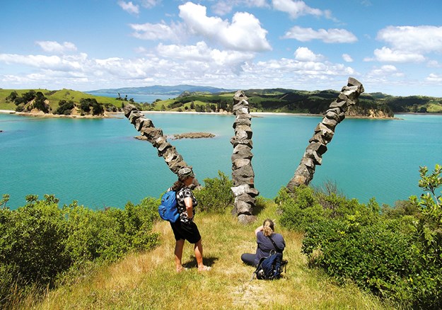
The Southern Loop Track takes around 75 minutes return from the Exhibition Centre. There are several lookouts, with stunning views of Home Bay, Ponui, Waiheke and the harbour. It’s steadily uphill, especially from Ruthe Point Lookout on, following the headland and partly through bush. A Chris Booth sculpture, three arcs of boulders strung together, sprouts from the ground near the tip of the headland. The work was commissioned in memory of Jack Plowman, father of Neal Plowman, one of the instigators of the Rotoroa Island Trust.
 |
|
A Chris Booth sculpture at the southern end of Rotoroa Island
|
On my return along the Southern Loop Track, I detoured to Men’s Bay, a golden sand, crescent-shaped beach where several launches and yachts were anchored in its clear, turquoise water.
Skink enclosures – fenced areas of kikuyu grass and flax to keep skinks safe from weka – lie on a flat area at the southern end of Home Bay. There’s information about the Moko and Shore skinks, but I failed to see these tiny lizards.
 |
|
The shed at the wharf on Rotoroa
|
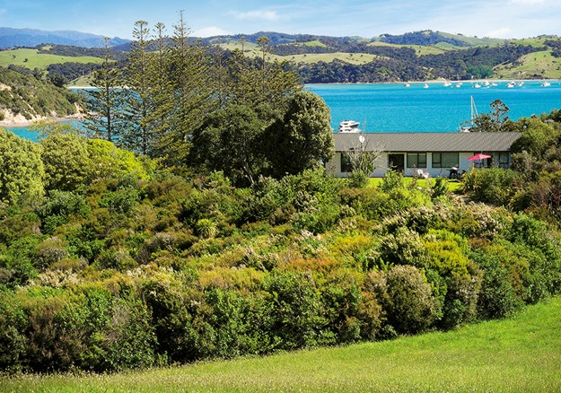
Having arrived on the island at 10am with quite a crowd, I saw few people in my 7¼ hours of almost non-stop exploring. Some chose to just relax for the day at the safe swimming beaches, while others had obviously come to stay a few days at one of the island’s three holiday homes, or in the Superintendent’s house.
When the ferry arrived at 5.15pm, to return to the city for 6.30pm, I wished I was one of those staying on this quiet, island paradise to enjoy a swim and take in the sunset, which apparently starts at one end of the island and ends behind Ponui. And then there’s the night sky, with little city glimmer … Next time!
 |
|
One of the holiday homes
|
To get to Rotoroa Island see:
fullers.co.nz
For accommodation on Rotoroa Island go to:
rotoroa.org.nz
Fullers Ferry stops at Orapiu Wharf on Waiheke Island an hour and fi ve minutes after leaving Auckland and continues on to Rotoroa Island, a 10-minute ride away.
Camp/campervan sites are available on Waiheke Island at Poukaraka Flats campground, Whakanewha Regional Park, around 13km from Orapiu. See: aucklandcouncil.govt.nz
For campervan/camp sites close to Auckland CBD see:
Avondale Motor Park: avondalemotorpark.co.nz
Tui Glen Reserve NZMCA Park (Henderson): nzmca.org.nz
Takapuna Beach Holiday Park: takapunabeachholidaypark.co.nz
Find motorhomes, caravans and RVs for sale in NZ

