 |
|
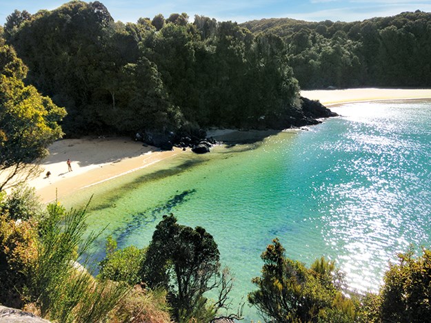
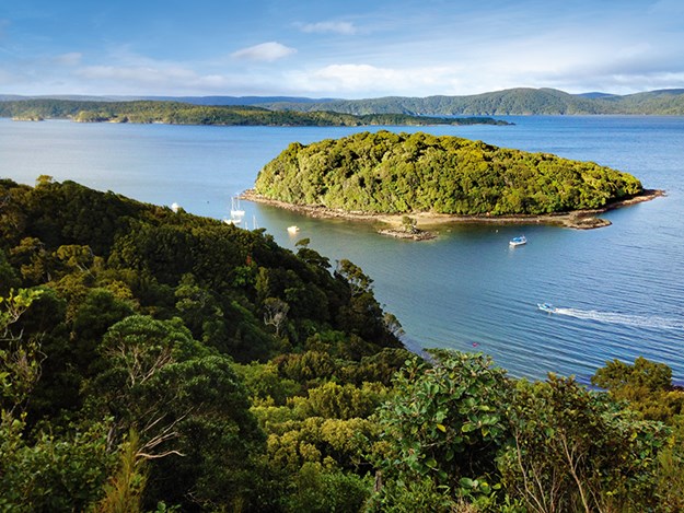
The stunning Bathing Beach; at low tide, you can walk around its curve to Mill Creek estuary
|
The first place I visited on 1746sq km Stewart Island was the Rakiura National Park Visitor Centre and Department of Conservation office on Main Road, Oban. I had pre-booked hut tickets to pick up for the three-day, 32km Rakiura Track, one of the country’s Great Walks. At the centre’s entrance a map showed the short walks around town.
Inside was chock-a-block with information on more tracks – under two hours, half and full day, the 125km North West Circuit, 71.5km Southern Circuit and the Rakiura Track. A week wasn’t long enough to cover them all, but I planned to walk a few.
Three days on Rakiura Track
The Great Walk can be tramped in either direction, but is usually started from Lee Bay carpark, 5km from Oban, at the entrance to Rakiura National Park. The other end is at Main Road/Fern Gully carpark, 2km from town. Taxis can be organised for pickup/drop-off to the track ends, but I walked.
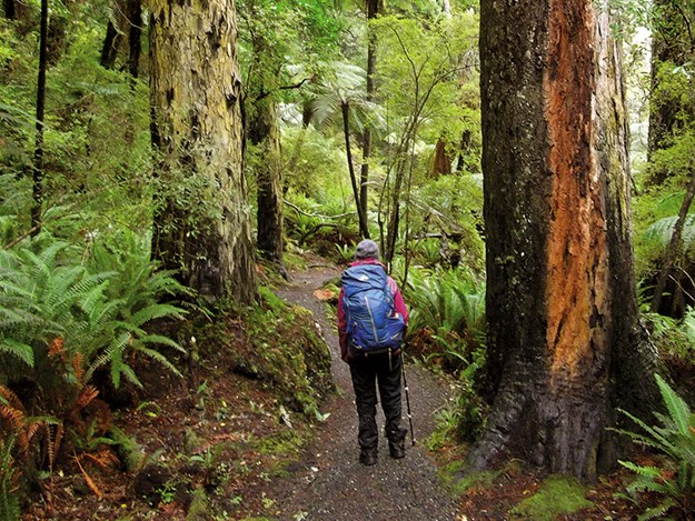
North Arm Hut took five hours to reach from Oban, on a relatively flat, 11km fine gravel track from the carpark. The high canopy of verdant native bush protected us from wind and rain. A short side-track emerged at Kaipipi Bay, sheltered by bush-covered fingers of land almost enclosing it. Bridges crossed bronze-coloured water, tannin-stained from rotting vegetation; we had seaviews at Sawdust Bay where mãnuka grew like a windswept hairdo; and an information board stood at an historic mill site. Twenty-four bed North Arm Hut is two minutes’ walk from a sandy beach and looks out across the sea to dark, bush-covered coastline. Wild deer grazed outside the hut, unbothered by us.
 |
|
A section of the Rakiura Track close to Port William Hut
|
The undulating track between North Arm and Port William Huts takes walkers through a never-ending green and, in September, black mud landscape. It was ankle-deep mud most of the way but, with lush forest and moss-covered tree trunks, was possibly Rakiura Track’s prettiest section. With persistent rain, water dripped from trees, down banks and onto the trail or formed rivulets on either side. Towering trees waved manically, creaking in the wind. Resembling locomotives, old log haulers abandoned since sawmilling finished in 1931 are a surprise in dense bush just before the Port William turnoff.
The last perhaps 1km of the six-hour, 13km walk gives views of Foveaux Strait. The hut, with boards on the walls telling of the area’s whaling, sealing and oyster history, is a short distance from the beach and wharf jutting into Port William’s bay.
Port William Hut to Lee Bay is 8.1km, approximately 2km of which is backtracking, and took around four hours. Gusts rocked the suspension bridge over the inlet that took us onto sweeping, sandy Maori Beach. At the far end of the deserted bay, nearby the campsite, were sawmilling relics and information on an area once a hive of activity. A continuous climb gave views of the coastline and seals, or sea lions, far below in clear, bluish-green coves.
 |
|
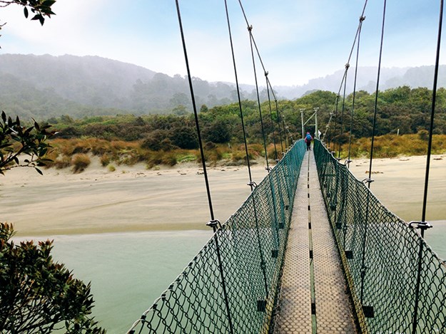
Crossing the suspension bridge to Maori Bay
|
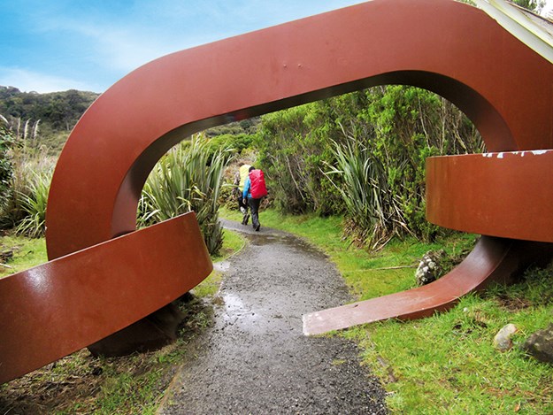
We descended to Lee Bay to walk along the beach to Little River, but at high tide we had to turn back and take the track there. The tannin-stained waters meeting the sea looked quite beautiful as I crossed Little River’s low bridge. The trail ended shortly after at a chain link sculpture which symbolises an anchor chain. The walk back to Oban is via road, skirting Horseshoe Bay where the few homes overlook the beach, then climbs uphill before descending into Halfmoon Bay, Oban.
 |
|
The Rakiura Track at Lee Bay, with its chain-link sculpture
|
 |
|
Oban from Elgin Terrace on the way to Ackers Point
|
Short walks from Oban
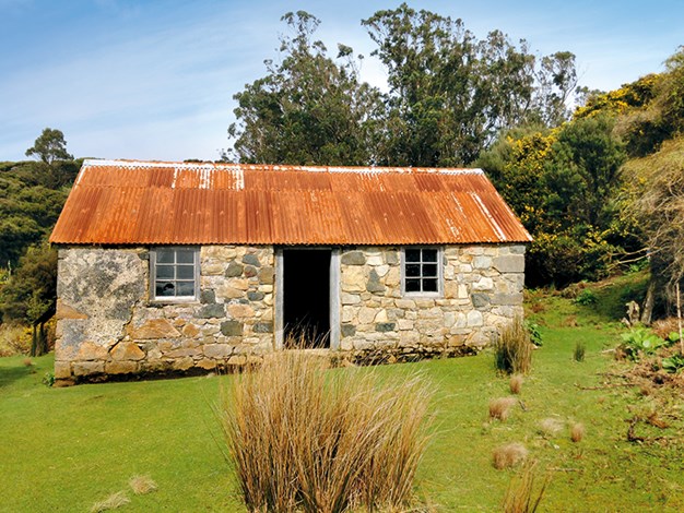
Back in Oban, we walked three hours return to Ackers Point Lighthouse. Following Elgin Terrace along the coastline of fishing boat-dotted Halfmoon Bay, we had views back to town and passed red and green boatsheds clustering two bays. At the road end, a five-minute track led to Harrold Bay, a secluded spot where one of New Zealand’s oldest stone buildings, heritagelisted Ackers Cottage, stands.
 |
|
Ackers Cottage, one of New Zealand’s oldest stone buildings
|
The easy walking track continued along bush-covered coastline to Ackers Point and the lighthouse – a modern, white rectangular building with a light on top. We gazed out to the islands in Foveaux Strait and read information on the original lighthouse, the little blue penguin, muttonbirds, and Titi Islands where Maori harvested (and still do) young muttonbirds.
For views over Paterson Inlet, where the open sanctuary of Ulva Island lies, we walked the scenic, coastal Golden Bay trail which undulates through bush, giving peeks of islands and Golden Bay. A kaka flitted past and landed in a branch just above me on the 45-minute walk.
Golden Bay Road gives access to Leonard Street, where Observation Point is located. This is around a 30-minute, uphill road walk from town. The panoramic view over Paterson Inlet and outlying islands with dark, bush-covered coastline rising beyond is stunning. It’s apparently a great spot for sunsets too.
 |
|
View from Observation Point
|
Fuchsia Walk is a pretty, fern-dotted, bush trail where wild fuchsia grow, not far from Halfmoon Bay waterfront. If you can’t do the Rakiura Track, this is a great taster. Unseen bellbirds and tui serenaded us on the 10-minute track, which ended at the rugby field. Across the field there’s access to the 20-minute Raroa Walk where massive rimu grow, mosses and ferns drape tree trunks, and there’s a punga which resembles a donkey, with a coat of ferns. This track ends on Thule Road opposite boatsheds lining Watercress Bay. Kayak hire is available here. A short walk, to the right, along Thule Road leads to sandy, secluded Thule Bay.
A 15-minute road and bush walk from town, passing the white Presbyterian church perched on a hill above Halfmoon Bay, led us to stunning Bathing Beach, a white sandy cove with clear turquoise water. At low tide you can walk the curved beach around to Mill Creek estuary. At high tide, we took the bush track at the top of the beach. A narrow inlet, Mill Creek was a mixture of tannin-stained and turquoise waters with a white sandbank across it. Beautiful. In September we found whitebaiters with full buckets along it.
The cemetery located along Mapua Road gives fantastic views over the creek. You’ll find Norwegian whalers graves’ and those of Stewart Island families such as Leask and Peterson, who have roads named after them.
Coast to coast
The Coast to Coast is a flat, 15.5km walk so it’s a perfect day trip… except if water levels are high. That necessitates spending a night, or more, in Mason Bay Hut or Freshwater Hut until flooding recedes and the track is walkable.
 |
|
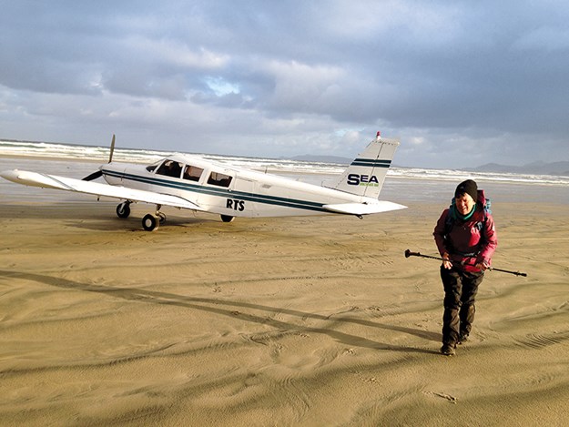
Landing at Mason Bay for the start of the Coast to Coast
|
The Coast to Coast is accessed via boat to Freshwater Landing at high tide or by plane to Mason Bay at low tide. We booked the trip through Stewart Island Flights, who also organised our water-taxi pick-up. Our eight-minute, 7.30am flight took us above turquoise coves, bronze-hued waters wending seawards and sand dunes before landing on the 19km sandy beach. Awesome!
Walking northwards past badly eroded dunes, and large tree trunks and debris scattered along the high tide mark, we reached Duck Creek and more rounded dunes. A sandy trail littered with buoys followed the creek between them. Wading shallow depths across the creek, we took the manuka-lined, road-width grassed path, once part of a 1930s constructed road from Mason Bay to Freshwater Landing.
My walking buddy had visited previously and seen kiwi here during the day, but we were out of luck. At empty Mason Bay Hut, a short distance away, a sign stated Freshwater Landing Hut was a three to four-hour walk. With the water-taxi scheduled for pick-up at 2pm, a brisk pace was required.
The grassed ‘road’ took us to Island Hill Homestead, 15 minutes away. Built in the 1880s and added to in the 1920s, looking little more than a simple bach, it was lived in by farmers until 1986. Further on, an old rusting tractor stood outside a historic woolshed. Information boards outside both the woolshed and homestead related their history.
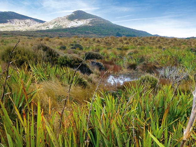
The trail narrowed, lined with orangey tussock and flax. Bush-covered hills rose beyond bush-dotted sand dunes. In places the track was mushy, a greenish-yellow moss covering it like velvet carpet. We walked through tunnels of manuka where mud necessitated going off track, then flax predominated followed by bush shaped by the wind. Bare-limbed trees stood in dark, perhaps knee-deep water known as the Chocolate Swamp, which a long boardwalk took us over.
 |
|
Leaving the sand dunes behind on the Coast to Coast
|
After a little under two hours of walking we reached a ‘Danger’ sign warning not to carry on if water was above its orange marker. At this point walkers need to return to Mason Bay Hut if it is, and stay overnight before trying again. The track was disappointingly bone-dry; I’d have been keen for a little wading adventure! Through a maze-like landscape of manuka, the track ran alongside a tannin-stained river which was sometimes still, sometimes running noisily.
Reaching the end of the ‘Danger’ zone an hour later, things got slushier with 10-15cm of mud in places requiring some careful stepping. At Freshwater Landing a jetty juts into black water. We arrived with half an hour to spare. Across a suspension bridge on the other side of the river was Freshwater Hut. Several people had been stuck there for two days, the water-taxi unable to pick up due to rough seas.
Zig-zagging along the twisting, narrow river, with apparently a mere metre of water below the boat, we emerged into Paterson Inlet to a view of rolling and jutting bush-clad land and choppy seas. A half-hour ride brought us to Golden Bay and the end of an enjoyable day of changing landscapes.
For short walks around Oban see:
Rakiura Track brochure:
For Coast to Coast information and bookings:
stewartislandflights.co.nz/coast-to-coast
For accommodation options, other than DOC huts around the island, see: stewartisland.co.nz/accommodation/