With Golden Bay at its centre, this northwestern corner of the South Island has some of the most memorable landscapes, flora and fauna of anywhere in New Zealand. The natural beauty of the area is enhanced by the surrounding Abel Tasman and Kahurangi National Parks.
Getting there
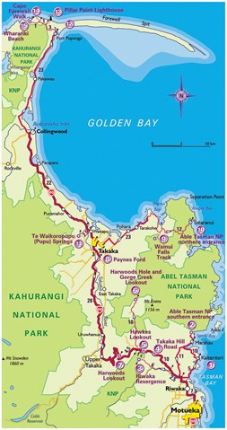
Starting at Motueka, 50km west of Nelson, the route includes the formidable Takaka Hill, Abel Tasman National Park and remote Farewell Spit. Most of the roads on this trip are sealed and are comfortable driving, although the narrow, winding, gravel road into Totaranui will take some care, especially in a camper van.
Best time to visit
This corner of the country has glorious summer weather which, combined with great beaches and a stunning landscape, makes it hard to go past Golden Bay as the ultimate natural New Zealand experience. As always, however, there is a downside, and in this region it’s the crowds. In January the main street of Takaka can be as busy as downtown Wellington, while at Totaranui the holidaymakers number in their thousands and the track over Takaka Hill is a steady procession of camper vans. Casual accommodation is almost impossible and the famed coastal walk in Abel Tasman is not only expensive but booked out well in advance. If you want to experience Golden Bay at its best then book early or try mid-March to June.
Facilities
The permanent population of the Golden Bay area is a few thousand, so facilities in general are pretty lean. Motueka is a good-sized town with a respectable range of accommodation, places to eat, shops and services. Places to stay at the beachside towns such as Kaiteriteri and Pohara are booked out well in advance, and this includes the camping grounds. The same goes for the huge camping ground at Totaranui in the heart of Abel Tasman National Park. Collingwood and Takaka are little more than villages and, again, if you plan to stay here during the peak of summer it pays to book ahead. But if all this sounds a bit gloomy and not worth the effort, it’s only because this particular neck of the woods is so beautiful. Plan ahead and make the trip.
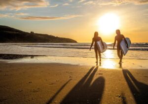
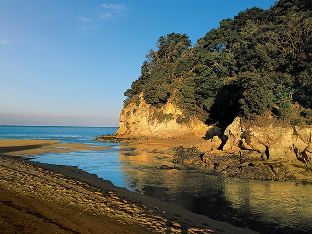
1. Kaiteriteri
Travel north from Motueka on SH 60 and after 7.5 km turn right into Kaiteriteri Road. Drive 5km to the beach. Kaiteriteri is a small crescent-shaped bay with deep golden sand and has long been one of the most popular beaches in the Nelson region. Tree-topped headlands shield the bay from most winds and frame stunning views that stretch across Tasman Bay.
 |
|
Granite rock headland, Kaiteriteri Beach
|
2. Abel Tasman National Park, Southern Entrance
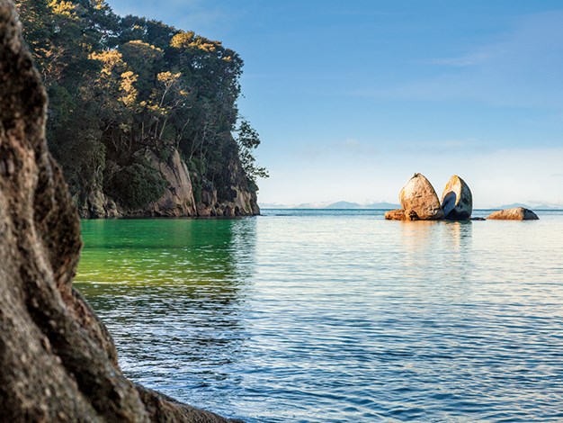
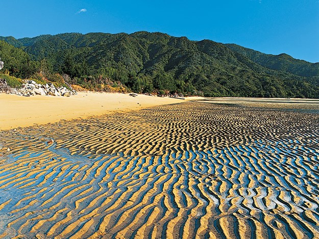
From Kaiteriteri head north for 10km on Sandy Bay Road to Marahau. Park by the café at the northern end of Marahau township. At just over 22,000 hectares, Abel Tasman National Park is New Zealand’s smallest national park, and in 1993 the area around Tonga Island was created a marine reserve.
In recent years it has gained a reputation as being one of the most crowded from December through to February. At the same time, the combination of lush bush, spectacular coastline, clear water and stunning sandy beaches make this park hard to resist.
The DOC Great Walk is a 51km-long coastal track of mainly easy walking, linking a series of stunningly beautiful beaches with some of the best coastal scenery in the land. Unfortunately, it is also one of the most popular (and most expensive) tracks, and by New Zealand standards extremely crowded in the busy summer months. If crowds bother you, don’t be put off walking in this area, just plan a trip outside the mid-December to mid-March period – although be mindful that at no time of the year are you likely to have the track entirely to yourself.
The two main access points are at Marahau at the southern end, and Totaranui (via Takaka) at the heart of the park, but all of the track is easily accessible by water taxi so you can create your own short walk from any point you like. Most water taxis are based at Marahau and Kaiteriteri near Motueka; starting from either of these places is a good option if you don’t want to drive all the way to Totaranui.
 |
|
Low tide, Marahau Beach
|
If you do choose one of these starting points, you get to see the magnificent coastal scenery on the way. The beginning of the walk at the Marahau River estuary is very tidal and attracts a good number of wading birds. Without using a water taxi, Coquille Bay is the most accessible attractive beach from the park’s southern entrance, and it will take around one hour to get there. Named after the ship commanded by French navigator Dumont d’Urville, who arrived in the northern part of the South Island in early 1828, Coquille Bay is a sheltered sandy beach backed by dense native bush and is ideal for swimming. Another popular option is kayaking around the coast; numerous operators at Motueka and Marahau offer kayaks and equipment for hire.
3. Riwaka Resurgence
Return 16km to SH 60 via Riwaka Road (this goes inland rather than back via Kaiteriteri). Turn right and drive 2.5km to the Riwaka Valley Road at the base of Takaka Hill. The Resurgence is at the end of this road, 6km from SH 60. A short bush walk through mature beech and fern leads to the base of a cliff where the crystal-clear waters of the Riwaka Stream emerge from under Takaka Hill, after flowing underground for 4km.
The cave is popular with divers, who can penetrate the stream underground for up to 800 metres, reaching a giant chamber with limestone formations. Although the water is very cold even in summer, there is a pleasant picnic spot by the car park for those not contemplating a dip.
4. Takaka Hill Road
Return to SH 60 and turn left. While not particularly difficult to drive, the Takaka Hill is 25km of slow winding road. Twisting and turning, this road between Tasman and Golden Bays has both spectacular views and fascinating geology. Famed for its distinct marble, the hill is also known as ‘Marble Mountain’, with stone quarried from the area used to build Nelson Cathedral, and both the old Parliament Buildings and the Beehive in Wellington. The highest point on the road is 972 metres.
5. Hawkes Lookout
From Riwaka Valley Road this lookout is 10km up the Takaka Hill Road, on the left. A short easy walk through bush and a landscape of rocky tors leads to a marble outcrop high above the Riwaka Valley, with dramatic views over Tasman Bay towards Nelson and the Riwaka Resurgence lying in the valley directly below. Almost directly across the road are the Ngarua Caves.
The remains of numerous moa have been found in this cave system and you can view a complete moa skeleton there (an entry fee applies). Sadly, there is also evidence of damage to the caves by 19th century souvenir seekers.
6. Harwoods Hole and Gorge Creek Lookout
One km from Hawkes Lookout turn right into Canaan Road. Follow this gravel, rough and narrow road for 10km to the car park at the very end. A dramatic tomo over 170 metres deep, Harwoods Hole is the deepest vertical cave shaft in the country.
The hole wasn’t properly explored until December 1958, and the following month the Starlight Cave, which leads from the bottom of the hole, was also discovered.
The track to the hole is an easy 45-minute walk through beech forest, though the path does become a bit of a rocky scramble towards the end. There are no barriers and the edge of the hole is a jumble of boulders that require a reasonable degree of fitness to negotiate.
It is actually quite hard to see into the hole, but soaring cliffs on all sides give a very good idea of its extent. Cavers regularly use the hole so don’t be tempted to throw rocks into the shaft.
Worth the time, a short side track leads up to the Gorge Creek Lookout. This lookout is located on top of a sheer escarpment with views over Gorge Creek and back towards the hole, a view that gives a better idea of the giant tomo’s scale. In the bush keep an eye out for tomtit, kakariki and robins.
7. Harwoods Lookout
Return to SH 60 and turn right. The lookout is 4.5km on the left, just below the summit on the Takaka side of the hill. Only a two-minute walk from the road, Harwoods Lookout has great views north over Takaka and Golden Bay as far as Farewell Spit. To the west are the peaks of the Lockett and Devil Ranges.
Excellent information boards detailing the geology and ecology of the region make this short stop worthwhile.
For the more energetic, the Takaka Hill Walkway from the summit is a 5km loop track that clambers through marble outcrops dating back over 400 million years.
8. Paynes Ford
Continue north on SH60 for 28km to Paynes Ford Bridge, which is 3km south of Takaka township. Following an old coach road, this track skirts spectacular limestone bluffs along the Takaka River and is an area popular with rock climbers. A maze of rough tracks that lead to dramatic cliff-faces, rocky overhangs and clefts in the limestone bluffs are worth exploring.
An erratic numbering system for them must mean something to someone, though there isn’t any information regarding the numbers anywhere nearby.
‘Number Four’ heads up a short track to a cliff-face where a rare native forget-me-not makes its home.
A swampy piece of ground along this track is home to the Rene Orchiston Collection of flax featuring dozens of varieties of harakeke that will not fail to impress.
When you reach the bend in the river the walk becomes a lot less interesting, so return to the car park from this point.
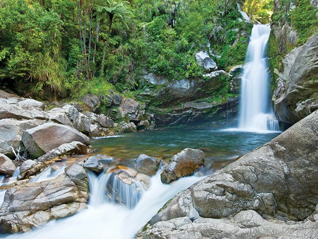
9. Wainui Falls Track
Continue 3km to Takaka and take the road to Totaranui via Pohara for 23km to the Wainui Inlet. Clearly marked on the right is Wainui Falls Road; turn into this road and travel 1km to the end and park.
The Wainui Falls are within Abel Tasman National Park and thunder over a 20-metre drop into a deep pool. While the falls are the main attraction, the stream and bush are impressive in their own right.
The forest is a lush mixture of mature beech, rata and nikau and the stream tumbles over huge water-worn rocks the size of small trucks. It is 30 minutes one way to the falls and the track is in good condition, though the wire suspension bridge might pose a minor challenge for those a bit unsteady on their feet.
 |
|
Wainui Falls
|
10. Abel Tasman Naional Park, Totaranui Entrance
From the Wainui Falls it is just 12km to Totaranui, though all of this is winding, narrow road and at least half the distance is gravel. It can get busy so take it easy.
The national park is named after Dutch explorer Abel Janszoon Tasman, who arrived in the area in December 1640.
The superlative ‘golden’ used to describe its sandy beaches does not really do the colour justice, though Golden Bay in fact takes its name from early gold strikes in the district and not the colour of the sand. All the bays along this coast possess a hemline of coarse sand the colour of burnt gold, made even more striking by the contrasting clear azure waters lapping their shores.
Typical is Totaranui Beach, a long stretch of beautiful coast with a huge camping ground, an information centre, and a boat ramp at its northern end. Totaranui is a particularly popular holiday destination and, despite the size of the camping ground, it is often booked out during summer. From here several other bays are within easy reach.
Anapai Bay, a 45-minute walk to the north through native bush thick with rimu, rata and beech, is a beautiful untouched beach with dark golden sand and stunningly clear water, ideal for swimming after a hot walk.
 |
|
Anapai Bay
|
From the southern end of Totaranui Beach a good track follows the coast to Skinner Point and then on to Goat Bay (20 minutes), a small sandy beach backed by native bush and also ideal for swimming. Waiharakeke (one hour) is a much longer beach with shimmering golden sand and features the lush subtropical bush for which this area is justifiably famous.
11. Te Waikoropupu (Pupu) Springs
Return to Takaka and take SH60 for 4km west. After crossing the Takaka River turn left and continue for a further 2.5km.
Claimed to be the clearest spring water in the world, these springs are not a single outlet but a series of eight interconnected vents in the main pool that discharge up to 14,000 litres per second at a constant temperature of 11.7°C.
The water is a mixture of salt and fresh water as the huge underground water system that supplies the springs extends far out under the sea. An innovative underwater mirror system allows the visitor a peek at life below the surface.
What is not so well known is that the springs are set in native bush that includes some fine old totara and rimu, and is home to native birds such as bellbird, tui and kereru.
12. Farewell Spit
From Te Waikoropupu Springs, return to SH60 and turn left, continuing 22km to Collingwood. Take Puponga Road north for 23km to Farewell Spit.
Over 30km in length, Farewell Spit is one of the longest recurved sandspits in the world.
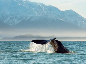
The delicate ecosystem of the area is home to a rich variety of bird life (over 90 species have been recorded), including migratory birds such as godwits, which arrive in their tens of thousands in the spring and feed in the shallow waters of Golden Bay. But the extremely shallow water is also a death trap for whales and the bay is the site of regular strandings, mainly by pilot whales.
At the end of the spit are an old lighthouse and a gannet colony. Puponga Farm Park, a working farm at the base of the spit, acts as a buffer to preserve the fragile ecosystem and is an area of outstanding beauty in its own right.
Only 2.5km of the spit is accessible to the casual visiting public and a loop walk that takes less than two hours includes the ‘inside’ beach of Golden Bay and the ‘outside’ beach, fronting the Tasman Sea.
At the southern end of the outside beach are rocky cliffs known as Fossil Point, where fossils are clearly visible in the mudstone. Little blue penguins and fur seals are also common.
There is an information centre and café with displays on the natural history of this unique locale (closed June to August).
In order to preserve the unique environment, access to the entire spit is only by guide tour run by Farewell Spit Eco Tours (FarewellSpit.com).
13. Pillar Point Lighthouse
From the Farewell Spit car park return 1km. Turn right into Wharariki Road and continue for 3km.
Winding through wind-stunted manuka, this track is a 30-minute uphill walk to a modern lighthouse with the best views over the area. To the west is Cape Farewell, directly north Farewell Spit curves far out into the sea, while to the east lie Golden and Tasman Bays. On a clear day Taranaki is just visible.
14. Cape Farewell Walk
Continue 1km to a farm road to the right; the car park is just beyond the woolshed.
A 10-minute walk up a farm track leads to a coastal lookout point atop sea cliffs with a huge rock arch and giant sea caves pounded by the waves far below. At 40 degrees 30 minutes south, this is the most northerly part of the South Island and lies directly east of the Manawatu in the North Island.
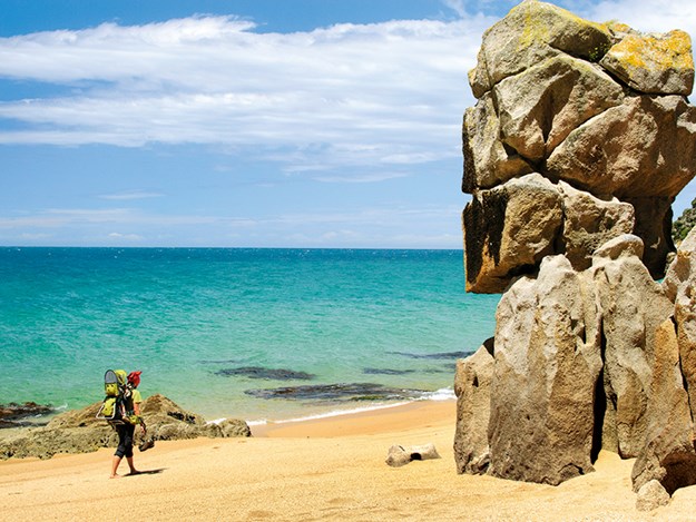
15. Wharariki Beach
Follow Wharariki Road for 1km to the car park at the very end.
Facing the heaving Tasman Sea, Wharariki is in marked contrast to the sheltered Golden Bay to the east. This beautiful wide sandy beach is flanked by dramatic rock formations blasted into shape by the wave-driven action of fierce and relentless westerly winds. Keep an eye out for lolling fur seals. This beach is definitely not safe for swimming.
More Information
Golden Bay Visitor Information Centre
Willow Street, Takaka
(03) 525 9136
Motueka i-SITE
20 Wallace Street, Motueka
(03) 528 6543

A New Zealander’s Guide to Touring Natural New Zealand, by Peter Janssen with photography by Andrew Fear, published by New Holland. Available at good bookstores now. RRP $39.99