Eleanor Hughes walks a landscape that is rich in history, and was forever transformed in 1886.
One of the largest lakes in New Zealand, the picturesque Lake Tarawera (meaning ‘burned spear), is famous for its size and beauty. It’s the largest of a series of lakes surrounding Mount Tarawera, and it’s a firm favourite with boaties, a great spot for trout fishing, with beautiful walkways and lakeside hot pools. It also claims a fascinating history. Te Maunga ō Tarawera is the spiritual home of Ngāti Rangitihi Iwi, who occupied the area around Lake Tarawera and nearby lakes. Descending from Rangitihi, the great, great grandson of Tamatekapua, the commander of the Te Arawa waka, which landed at Maketū from Hawaiki, they are the kaitiaki (guardians) holding mana whenua (the right of management) of the sacred mountain. I walked in their footsteps over a weekend.
Some of my hiking buddies remembered hiking Mount Tarawera decades ago when it was free to do so. Apparently visitor numbers got up to 40,000 a year and tonnes of rubbish was left behind. Today, walkers must book a tour with Kaitiaki Adventures.
The eruption
After being picked up from Te Puia carpark in Rotorua at 8.15am for their 4½ hour tour, we headed south on SH5 then east on SH38. Rural roads took us to Crater Road where a private dirt road pitted with potholes had us bouncing in the 4WD bus as we ascended through pine forest then native forest. Where bush cleared, Eddie, our guide, pointed out Lake Rotomahana, home to one of New Zealand’s earliest tourist destinations, referred to as the eighth Wonder of the World, the Pink and White Terraces. But the mountain I was on destroyed them.
According to Māori legend, although versions differ, Mount Tarawera’s eruption was caused by Tuhoto Ariki, a Māori priest, who believed local Māori’s morals were being corrupted by Europeans. He called on the evil god, Tamaohoi, who had dwelled on the mountain for centuries, and Ruaimoko, the god of earthquakes, to punish them by raining death on the land. Eleven days before the fatal explosion, Lake Tarawera reportedly rose then subsided within minutes. Both European and Māori described seeing a waka being paddled across the lake, paddlers wearing huia and white heron feathers, associated with death, in their hair. Never had such a boat been sighted on the lake before. It was considered a sign of impending disaster.
The eruption occurred in the early hours of 10 June 1886, and was heard from Kaikōura to Auckland. Mud, boulders and black ash were thrown up from a 17km fissure. Nine villages including Te Wairoa, now the Buried Village heritage attraction, were destroyed; 153 people lost their lives. Nearing the crater, where low, white-flowered manuka grew in the dry landscape, views widened. Mt. Edgecumbe dominated. Plumes drifted up, possibly from the Kawerau Geothermal Station to the north of it. In the haze, I could just make out Whakaari/White Island, Moutohora/Whale Island more conspicuously, on the East Coast.
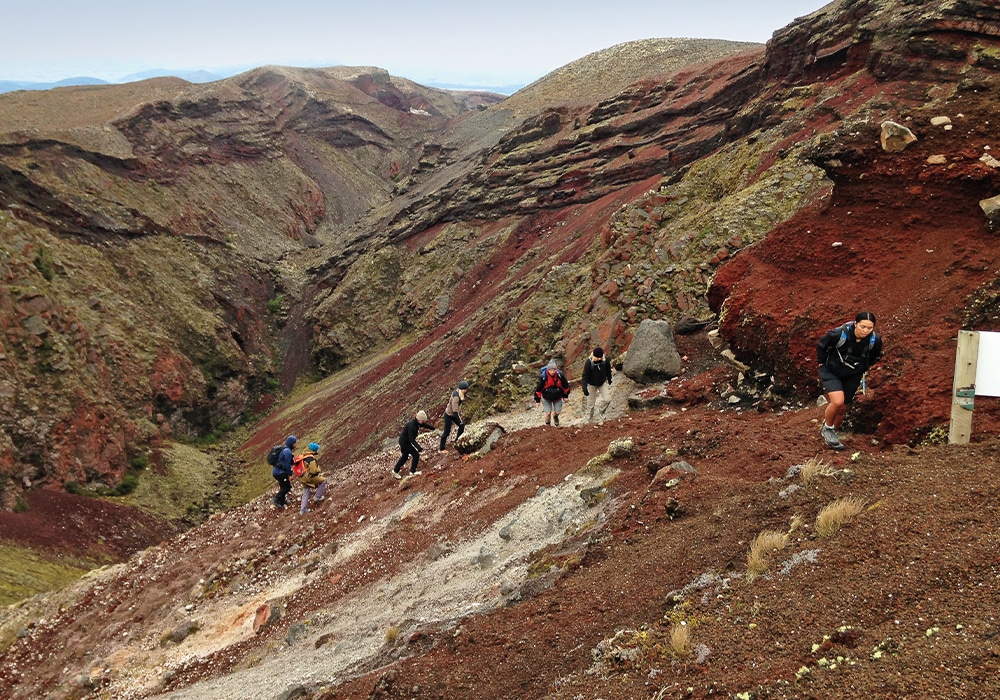
The crater walk
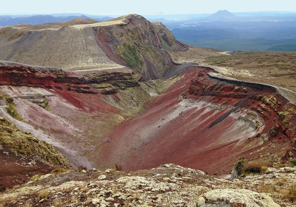
Mount Tarawera has three domes. To our left was Tarawera, in the middle of Ruawahia, the summit at 1.1km above sea level. According to Māori, they are the male aspects of the mountain. Flat-topped, Wahanga to the right, the female, was a Ngati Rangitihi burial ground before the eruption. The dead, wrapped in ceremonial cloth, were placed in the river or lakes in the area they hailed from, seen as giving back to the waterways that had sustained them throughout their lifetime. Water decomposed the flesh, fish and eels fed on it. The bare bones were then placed on Wahanga.
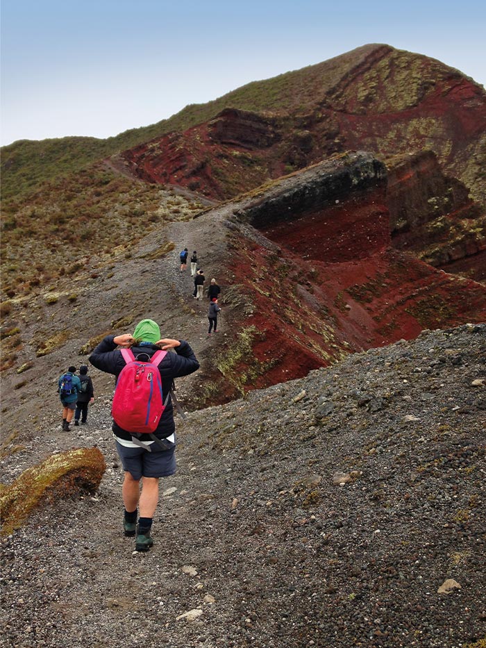
Alighting the bus, Eddie began our two-hour, three-kilometre walk with a karakia – a prayer of thanks to those who had passed for leaving the taonga (treasure) and everything around us, and for sharing their maunga (mountain). He asked them to watch over us as we explored.
Grey scoria crunched underfoot; vegetation grew low and sparse across the rocky terrain. A falcon soared above; the wind chilled. Reaching the crater rim, I looked down into the vast, 120m deep interior. Streaked with pale shades of pink, crimson, rust, grey, black and white it appeared as if paint had been poured from the rim and run down. Flora in green hues clustered here and there. Stunning. On the rising trail skirting the rim views were ever-changing; colours intensified. A narrow, red scoria path led to the saddle where wind battered and a steep, rugged valley of red, grey and green lay to our left. I clambered up a short, steep section known as the Hillary Step, loose, smallish rocks occasionally tumbling, to witness the most spectacular colours yet. Wahanga back-dropped the expansive crater.
Summit and crater
Rising 200m overall from the start, we reached Ruawahia summit where the red scoria terrain was broken by mounds of whitish green lichen. Far below, lakes lay serene, the vast Tarawera in the foreground, two others beyond separated by grassed and forested land. Cloud blew in obscuring the scene then dispersed. Downhill on loose, fine rock, I dug my heels in first at each step to stop from sliding. Eddie instructed us to lean back, on the steep, grey scree slope leading down into the crater. Then he was off, bounding, sliding, almost out of control. I followed more slowly, the slightly-bigger-than-sand granules coming to around shin deep. It was like running down a sand dune.
Deep-red scoria, pinkish rhyolite, black basalt and chunks of white rock vividly covered the base. Feeling insignificant below towering, multi-hued cliffs, I walked the narrow rocky valley to ‘The Punisher’, a flight of sometimes too high stairs to the rim. I took one last look down. It would have been dramatic when erupting, and it is still dramatic in dormancy.
Tarawera Trail
The following day, our plan to walk the 15km trail to Hot Water Beach was thwarted by a trail slip. Totally Tarawera’s water-taxi instead picked us up from Te Wairua Bay, giving us an 11km walk. Lake Tarawera was formed 5,000 years ago when lava flows blocked it; the Māori legend, however, is more romantic. Putauaki, Mount Edgecumbe, was once married to Tarawera but deciding he’d rather be with Whakaari, White Island, he set off. Daylight caught him, fixing him to where he now stands and Tarawera wept. Where he had stood beside her filled with tears, forming Lake Tarawera.
Walking the trail
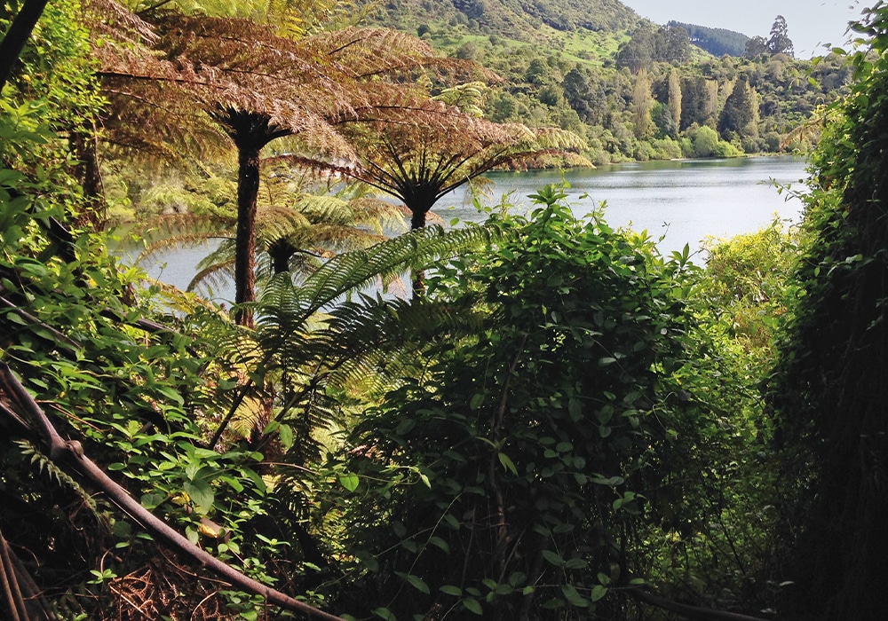
The damp trail led gently through dim, native bush, and it wasn’t long before we glimpsed, through foliage, distant Wairere Falls, situated near the Buried Village. Between Mamaku fronds, Lake Tarawera shimmered silver amongst green-forested headlands. Slightly further on, the Landing Café and a jetty came into view across Kōtukutuku Bay’s bluey-green water. From a high point, dark and foreboding Mount Tarawera to the east dominated the horizon. Dense, verdant native bush was replaced by a flat trail between bare Manuka trunks, the canopy high above. On the coarse sand shoreline of Hawaiki Bay, the water was crystal clear. Five boats anchored were too distant to see if rainbow trout were being hauled aboard.
Mount Tarawera’s slopes revealed a little colour, the whitish green lichen appearing like settled snow. The lake mirrored foliage; we walked below steep rock cliffs and through cool forest, crossing a flat area that appeared to have flooded, a wide ‘river’ of dried, brown mud left behind. Three kilometres and an hour on from Hawaiki Bay, with a bit of puffing, I reached Oneroa Lookout to view the lake’s northern end and Makatiti Dome.
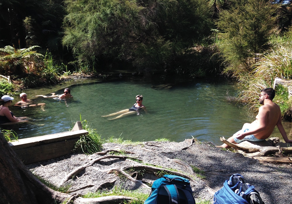
Heading inland and descending, Wairua Stream was reached at a steady pace 30 minutes later, 31⁄2 hours after setting out. A makeshift sign stating ‘Hot Pool’ pointed to the left. I contemplated continuing to Rotomahana Lookout then returning. The elevation guide on the trail sign showed a short, sharp 150m ascent, a 1km, supposedly 40 minute walk. It had taken us longer than the stated times for each location…the hot pool won.
Hot Pools
A five minute walk brought us to a rock- edged pool in Wairua Stream where others were already soaking, having arrived at Te Wairua Bay by private boat. The pool was plenty big enough for 20 or more. Sitting on the pool’s shingle bottom, warm water chest-deep, I watched tiny fish, maybe two centimetres long, dart around my legs. At times a thin, turquoise line edged the outline of limbs underwater…something to do with chemicals…reflection… refraction…?
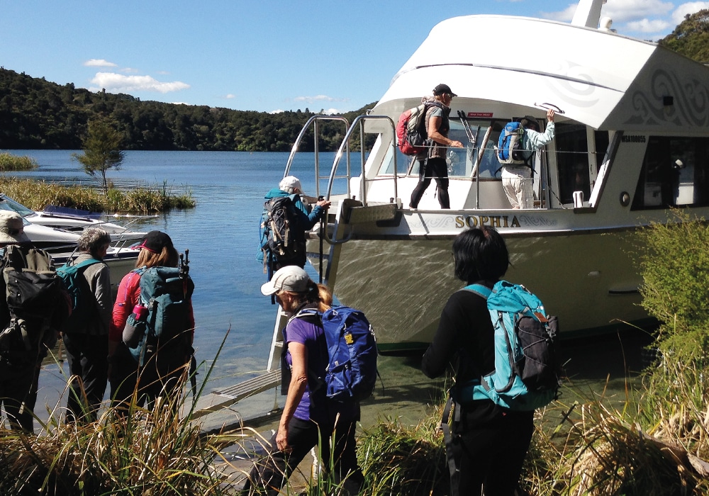
It was a blissful way to end the hike. Sophia, Totally Tarawera’s boat, named after the famous Māori guide who led tours to the Pink and White Terraces, arrived at 3.30pm. With three further passengers booked but missing, the skipper cruised around to Hot Water Beach in search of them. Steam drifted off the water close by one end of the long, sandy beach where rocks surrounded a pool on its edge. Apparently, the sand gets so hot, you can dig a hole and cook your food in it… handy for those camping at the campsite, which is accessible only by boat or the trail. The missing passengers weren’t there.
We motored across the lake to Kariri Point Reserve/Boat Shed Bay. To starboard, stark above the dense bush rimming the lake, Mt Tarawera loomed, its exquisite colours hidden within. On the five-minute shuttle drive back to Tarawera Trail car park we passed by Te Wairoa, the village Tarawera buried. I should’ve walked in its long gone inhabitant’s footsteps too…
More info
- Mt. Tarawera Crater Walk: kaitiaki.co.nz
- Rotorua Thermal Holiday Park is handiest for both the trail and pick-up for the crater walk: nzmca.org.nz
- Tarawera Trail has since reopened but check doc.govt.nz for regular updates before setting out.