 |
|
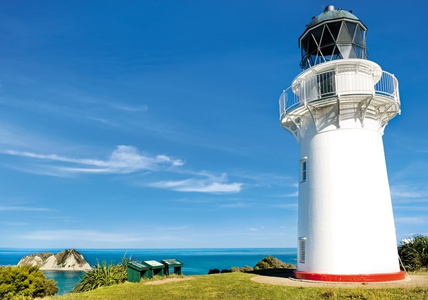
East Cape lighthouse
|
Even by New Zealand standards, the East Cape and Poverty Bay are remote, but therein lies the region’s greatest appeal: uncrowded beaches and an unhurried atmosphere, all in an unrivalled climate.
GETTING THERE
The trip can begin from Opotiki, a good five to six-hour drive from Auckland, or Gisborne if you are coming from the south, an even longer drive from Wellington and a three- to four-hour drive from Napier. SH 35 around the cape is a good sealed road and, while not fast, is easy travelling. Side roads are almost all gravel, but none are especially long or arduous.
BEST TIME TO VISIT
The popular visitor season is strangely short in this region. New Zealanders pack out the East Cape and Gisborne from mid-December through to the end of January, the traditional school holiday period. As the region doesn’t attract so many overseas visitors, February and March are a glorious time on the East Cape: the weather is hot and sunny, the sea is warm and inviting, accommodation is easy, and this is the perfect place to relax. Winters can be cold, particularly with weather from the south, but they are usually short.
FACILITIES
While Gisborne has plenty of services, cafes and places to stay, the cape along SH 35 is another story. Camping is plentiful (there is an especially lovely camping ground at Anaura Bay), but motels and other accommodation are extremely limited. If you have any intention of staying anywhere between Opotiki and Gisborne, especially during the summer, then you have to book ahead.
(Both Gisborne and Opotiki have good visitor centres and they will be able to help.) Likewise, the East Cape has little in the way of facilities, with very few cafes and just the occasional general store. It is best to leave Gisborne or Opotiki with a full tank of petrol as, while the general stores sell petrol, it is much more expensive than in the larger towns.
 |
|
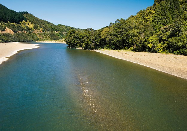
Motu River
|
1. MOTU RIVER
SH 35 CROSSES THE MOTU RIVER 40KM FROM OPOTIKI.
State Highway 35 crosses the Motu at the point where the river ends its tempestuous journey to the sea. Rising in the Raukumara Ranges, this wild river is one of the last untouched waterways in the country, running for almost its entire length through deep gorges and steep, bush-covered hills. One of the last rivers to be explored in New Zealand, in 1919 an expedition party travelled down the Motu and took 10 days, ran out of supplies, and was eventually met by a rescue party.
The Motu River is now protected from any further development by a special Act of Parliament, which has created a Wilderness Zone around it. Today it is very popular with experienced kayakers and whitewater rafters. Jet boat trips up the river are available, leaving from the Motu River Bridge on SH 35.
2. CAPE RUNAWAY
FROM THE MOTU RIVER, CONTINUE 73 KM ALONG SH 35 TO WHANGAPARAOA BAY, WHICH LIES IN THE LEE OF CAPE RUNAWAY.
Cape Runaway is the most northerly point of the East Cape region and marks the boundary between the eastern Bay of Plenty and the Gisborne side of the cape. Usually treated as one entity, the East Cape in reality is two distinct regions, both in landscape and climate.
From Opotiki to Cape Runaway, the road hugs the rugged coast, weaving in and out of sandy bays and small rocky coves. The area, open to moist northerly winds, has high rainfall, resulting in fast-flowing rivers and bushclad hills. In contrast, the eastern side of the cape is much drier, and the bush, cleared in the 19th century, has struggled to return. The road is mostly inland, touching the coast occasionally, but on this coast the beaches are wider and more sheltered.
 |
|
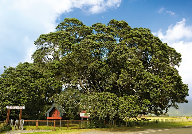
Te Waha o Rerekohu, possibly the world’s largest pohutukawa
|
3. TE WAHA O REREKOHU POHUTUKAWA, TE ARAROA
TE ARAROA IS 42KM FROM CAPE RUNAWAY, JUST OFF SH 35.
Reputedly the largest pohutukawa in the world, this massive tree, known as Te Waha o Rerekohu, is almost at the southern natural limit of the species. Spreading over a wide area on the beach at Te Araroa, the tree is 20 metres high and 40 metres at its widest point and estimated to be over 600 years old. Te Waha o Rerekohu is tapu (sacred) so do not climb it.
4. EAST CAPE
THE CAPE IS 20KM EAST OF TE ARAROA VIA A WINDING GRAVEL ROAD.
The East Cape, together with the small offshore East Island, is the most easterly point of the North Island of New Zealand (the Chatham Islands are in fact the country’s most easterly territory, and are sometimes described as ‘the last place on earth’). A lighthouse built in 1922 on a 150-metre hill has great views over the surrounding coast.
 |
|
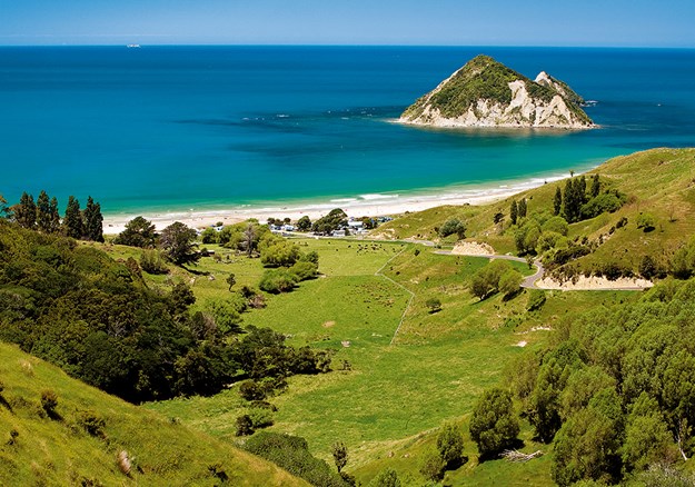
Anaura Bay with Motuoroi Island off the coast
|
5. ANAURA BAY
SH 35 CONTINUES SOUTH FOR 103KM TO THE ANAURA BAY ROAD TURNOFF, FROM WHERE IT IS 7KM DOWN TO THE BEACH.
Anaura Bay is a stunning crescent of white sand, with the tiny Motuoroi Island standing just offshore. The bay is widely regarded as having one of the finest unspoilt beaches on the East Cape. Behind the bay is Anaura Bay Scenic Reserve, 225 hectares of rare native forest, including fine stands of mature puriri, kahikatea and titoki. A loop walk through the bush will take around two hours, and from a lookout there are fine views over the bay.
6. WILD STINGRAY FEEDING, DIVE TATAPOURI
RETURN TO SH 35 AND CONTINUE SOUTH FOR 53 KM TO TATAPOURI.
Lying just 100 metres off Tatapouri Beach is a reef that becomes exposed at low tide, and it is here that Dive Tatapouri has developed a unique attraction.
The area is home to stingrays that live in the deep channels of the reef to avoid predators and, attracted by regular feeding, will come right up to people and feed from their hands. Mainly eagle and short-tailed rays, the largest of the regular ray visitors is Brutus, who is estimated to weigh around 200kg. The regular food also attracts other sea creatures such as the shy conger eel, kahawai, kingfish and the very occasional orca (which have an appetite for stingray!). The trip to the reef is tide and weather dependent (ph 06 868 5153, www.divetatapouri.com).
7. MAKORORI POINT AND BEACH
MAKORORI BEACH IS 2KM SOUTH OF TATAPOURI.
North of Gisborne is a string of beautiful sandy beaches best known for their lively surf. Most are developed to some degree, apart from Makorori just north of Wainui Beach, though in reality there is plenty of space along this coast for everyone, even at the height of summer.
Between Makorori and Wainui Beaches is Makorori Point, where a short walk to a lookout has spectacular coastal views to the south, beyond Young Nicks Head to the Mahia Peninsula and to the north over Makorori Beach. On the other side of SH35 from the point is Okitu Bush Scenic Reserve, a small coastal forest remnant. It takes around 20 minutes to walk the loop track to a lookout.
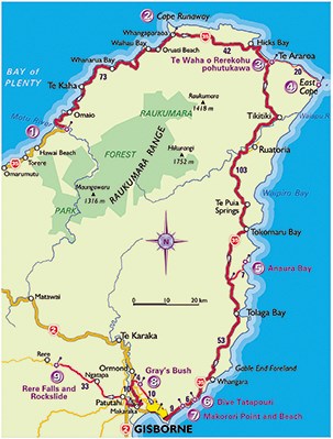
8. GRAY’S BUSH
DRIVE FROM MAKORORI TO GISBORNE, 9KM ON SH 35.
From Gisborne take Back Ormond Road for 10km to Gray’s Bush. The only remaining lowland bush on the Poverty Bay plain, Gray’s Bush is a subtropical forest with an understorey of nīkau palms and massive kahikatea and puriri. The combination of the latter trees is unusual in that the puriri tends to favour well-drained soils, while kahikatea thrives in wet conditions. Early recognition of that unique forest combination saved this bush from the axe. Furthermore, the height of the kahikatea has resulted in the puriri growing much taller and straighter than their usual spreading habit.
9. RERE FALLS AND ROCKSLIDE
FROM GRAY’S BUSH CONTINUE ON BACK ORMOND ROAD FOR 4KM TO THE INTERSECTION OF SH2, TURN LEFT AND DRIVE 10KM TO MAKARAKA. AT MAKARAKA TURN RIGHT AND CONTINUE ON SH 2 FOR 5KM. AT THE WAIPAOA BRIDGE ROUNDABOUT TURN RIGHT AGAIN AND FOLLOW THE WHAREKOPAE ROAD FOR 33 KM TO RERE FALLS.
No more than 6 metres high, the Rere Falls make up for a lack of height by being particularly picturesque. Here the Wharekopae River tumbles down an escarpment to form a broad waterfall, made extra appealing because behind the tumbling veil is a cave hollowed out over aeons by the constant action of the water. The swimming hole is a particularly welcoming spot in summer and the falls area has a large grassed picnic area. Just upstream is the Rere Rockslide, a 60-metre cascade of water and very popular as a natural water slide. A boogie board, wetsuit or something robust to slide on is essential.
A New Zealander’s Guide to Touring Natural New Zealand, by Peter Janssen with photography by Andrew Fear, published by New Holland. Available at good bookstores now. RRP $39.99